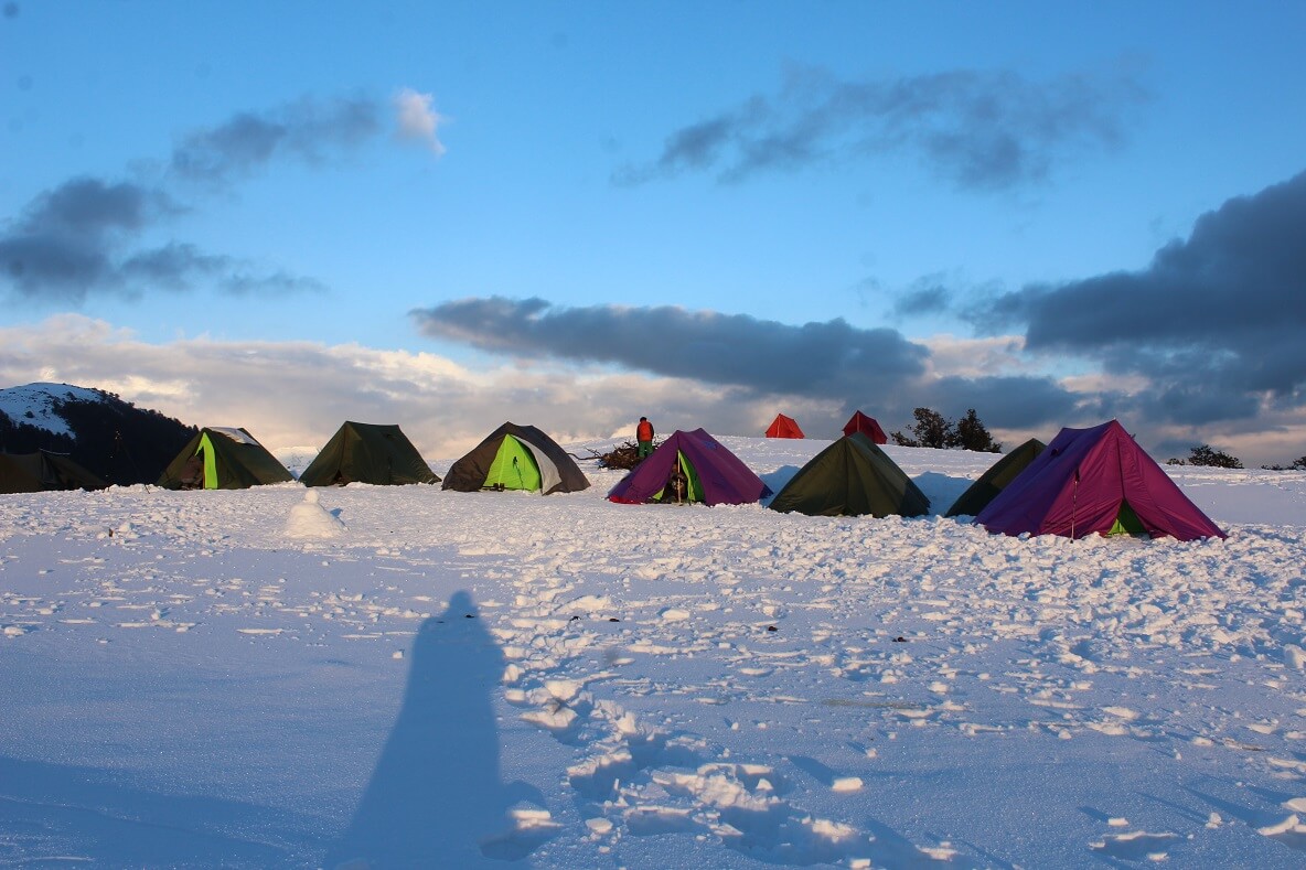
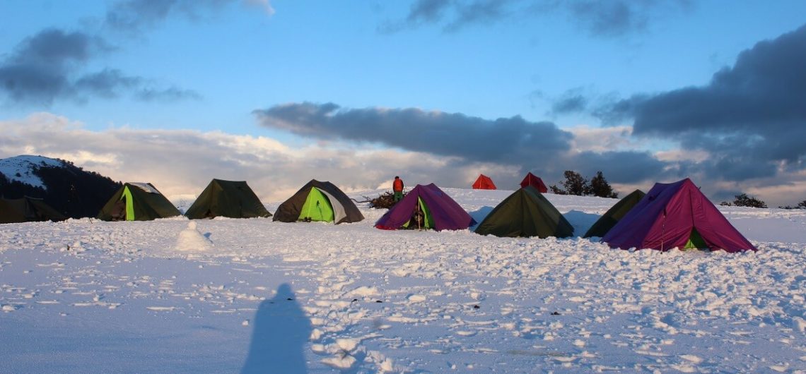
Hampta Pass Chandratal Trek Distance, the drive from Manali to Chika 7 km. The total trekking distance of Hampta Pass Chandratal Trek from Chika is 26 km. Undoubtedly Hampta Pass Chandratal Trek is the most beautiful trekking destination in the world. It offers the beauty of the snowy trekking trail with the incredible view of the snowy peaks.

Chandratal Lake Trek has to be in every trekker’s list who dreams of conquering the high altitude trek. The Hampta Pass Trek is open in summer months from June, July, August, September, and October.

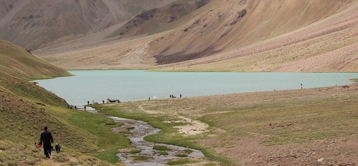
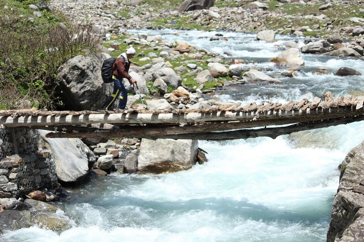
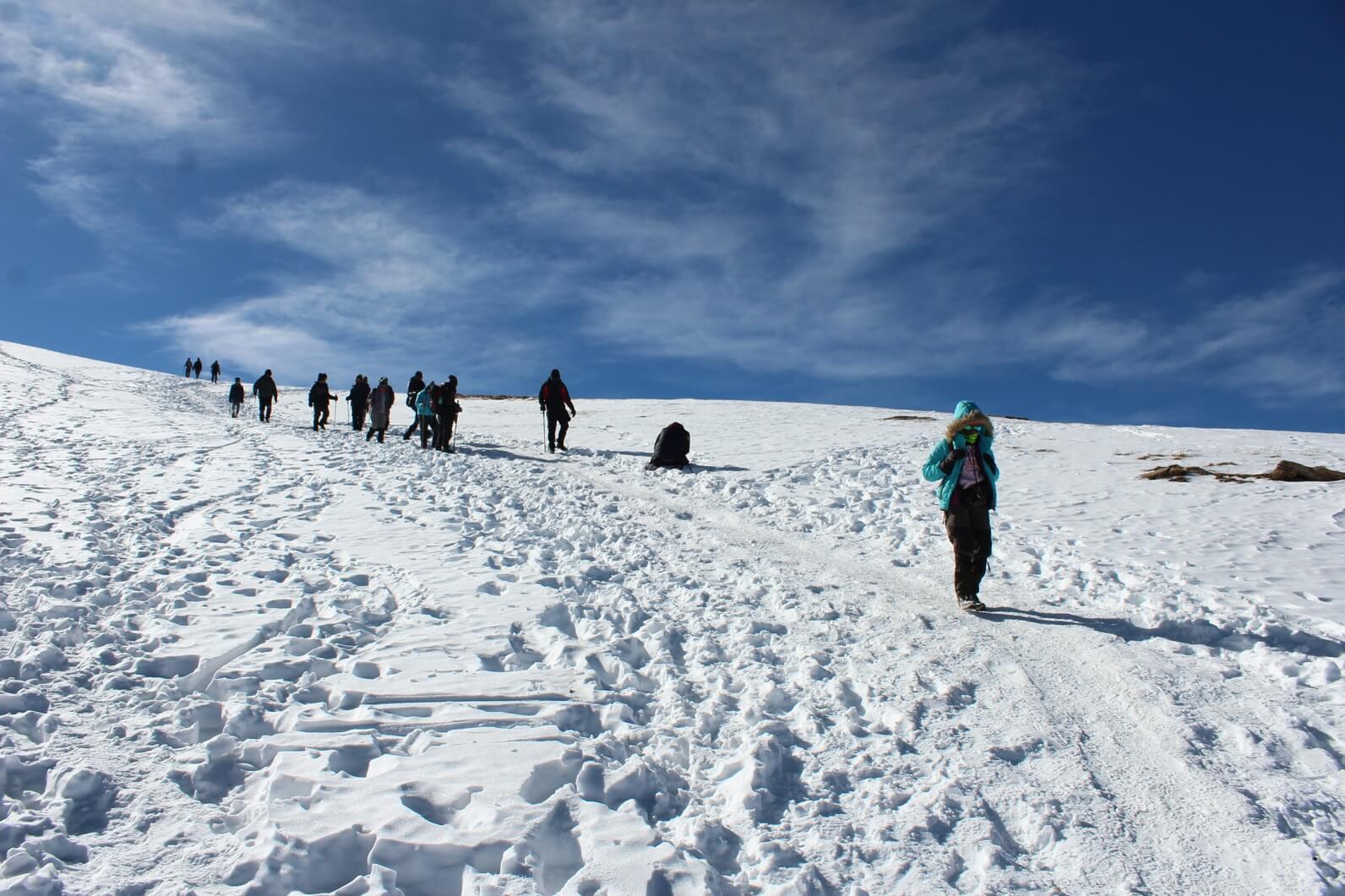
Trekking in Himachal Himalaya is perfect for adventure lovers and one who wants to enjoy the natural beauty. At the height of the 14,100 feet above sea level, you can also catch majestic snow-clad peaks. The trekking route through rivers, wildflowers, green landscapes and wonderful backdrop of the mountain peaks. Hampta Pass Chandartal lake Trek is also one of the best easy treks for beginners.


Hampta Pass Chandartal Trek Distance

The Hampta Pass Chandratal Trek distance from Manali to Chika: 7 km drive

Chika to Balu ka Ghera: 5 km

Balu Ka Ghera to Shia Goru: 6.65 km

Shia Goru to Chatru and drive to Chandratal: 6 .87 km


Hampta Pass Chandratal Trek Route:

Manali – Chika – Balu ka Ghera – Shia Goru – Chatru – Chandratal Lake


Hampta Pass Chandratal lake Trek Best Time

June, July, August, September, and October is the best time to visit Hampta Pass Trek.


Trek Essential for Pangarchulla Trek

  • Trekking shoes
  • Head Torch
  • Winter Jacket
  • Quick-dry trek pants
  • Hand Gloves
  • Woolen socks

Hampta Pass Chandratal Trek Short itinerary

Day 1: Drive from Manali (9,800 ft) to Chika (11,072 ft); 5-6 hours, 7 km

Day 2: Chika (11,072 ft) to Balu Ka Ghera (11,900 ft); 4-5 hours, 5 km

Day 3: Balu Ka Gera (11,900 ft) to Shia Goru (12,900 ft); 9 hours, 6.65 km

Day 4: Trek from Shia Goru (12,900 ft) to Chatru (11,000 ft) and drive to Chandra Tal (14,100 ft), 4-5 hours, 6.87 km

Day 5: Drive from Chandra Tal to Manali


Chandratal Trek Best Time- Hampta Pass Chandratal trek is the best summer trekking destination in Uttarakhand Himalaya. Summer is the perfect time to enjoy the beautiful trekking trail with the perfect view around.  The trekking trail is incredible and the scenery will be rewarded with are utterly breathless.

Which is the best time to visit Hampta Pass Chandratal Trek?

Hampta Pass Chandratal Trek best time is in the summer season. The best time to visit Hampta Pass Chandratal trek is June, July, August, September, and October. During this season, trekkers can enjoy camping in the tents and view of the snowy mountain peaks. During these months, one can see the natural beauty and stunning views of the mountains like Deo Tibba, Indarshan mountains.

Peaks visible from the Hampta Pass Chandratal Trek?

Hampta Pass trek is the best trekking destination at the height of 14,100 feet above sea level. It is an amazing climbing spot in Himachal Himalaya. Trekkers can see the mesmerizing view of the Mt. Deo Tibba and Mt. Indarsan.


Hampta Pass trekking trail facts

The trekking trail is 26 km long from Chika and requires easy to moderate level fitness. The Chandratal trek starts from Manali, which is a place where many trekking trails start. Like Hampta Pass trek, Bhrigu lake trek, Friendship Peak Trek.

Chandratal trek best time is in summers when the trekking trail is overwhelmed by the natural landscapes, flora, and fauna. The highest point of the Chandratal trek is 14,100 feet above sea level. Hampta Pass Chandratal trek in Himachal Pradesh is special in many ways but what makes it so unique from the other treks in India is the beautiful lush green Kullu valley and the barren desert of Spiti  Valley.


Hampta Pass Chandratal Trek short itinerary

Day 1: Drive from Manali (9,800 ft) to Chika (11,072 ft); 5-6 hours, 7 km

Day 2: Chika (11,072 ft) to Balu Ka Ghera (11,900 ft); 4-5 hours, 5 km

Day 3: Balu Ka Gera (11,900 ft) to Shia Goru (12,900 ft); 9 hours, 6.65 km

Day 4: Trek from Shia Goru (12,900 ft) to Chatru (11,000 ft) and drive to Chandra Tal (14,100 ft), 4-5 hours, 6.87 km

Day 5: Drive from Chandra Tal to Manali

Full itinerary of Hampta Pass Chandratal Trek

Chandratal Weather- Chandratal lake trek is well known for its beautiful lake. The trekking trail is through the green valleys. Hampta Pass Chandratal Trek is best in the summer months. The best time to visit Hampta Pass Trek in June, July, August, September, and October. You can also see the majestic peaks on this trek.

The Hampta Pass Trek is located in Himachal Pradesh. It is one of the easiest treks to visit in Himalaya and also the best trekking destination for summers. One may see the wonderful crossover from Manali to Spiti.

Trekkers can see the mesmerizing view of the snow-clad mountains which is sure to leave you in awe. Camping of the Hampta pass trek is most beautiful under the star-studded sky. Chandratal weather plays a very important role when you are planning to go on the summer trek.


Chandratal Temperature

The Chandratal weather plays a very important role when you are planning to go on the summer trek. The maximum temperature of the Hampta Pass Chandratal trek will be 15 degrees Celsius.

Temperature in June is 15 degree Celsius.

The temperature in July 18 degree Celsius.

Temperature in August is 18 to degree Celsius.

The Temperature in September is 15 degree Celsius

Temperature in October is -2 to +10 degree Celsius

hampta pass chandratal trek


Why summer is the best time to visit Hampta Pass Chandratal Trek?

During summer, Himachal Himalaya offers some of the most beautiful snowy trekking trails with the incredible landscapes. Chandratal weather is one main attraction of this summer trekking trails in Himachal Himalaya. This amazing trekking destination offers a fascinating vista of snowy mountains and the screen place to nurture soul and mind.

Looking for summer trekking destination in Himachal Pradesh?

Hampta Pass Chandratal trek is a perfect place for you to enjoy the summer season and it also offers natures’ beauty at its best

Chandratal Best Time

Hampta Pass Chandratal Trek full itinerary

Chandratal Lake Weather

The Chandratal Temperature


Pangarchulla Trek Distance, the drive from Dehradun to Joshimath 220 km. The total trekking distance of Pangarchulla Peak Trek from Joshimath is 27 km. Undoubtedly Pangarchulla Trek is the most beautiful trekking destination in the world. It offers the beauty of the snowy trekking trail with the incredible view of the snowy peaks.

Pangarchulla Peak has to be in every trekker’s list who dreams of conquering the high altitude trek. The Pangarchulla trek is open in winter months from February to May.

Trekking in Uttarakhand is perfect for adventure lovers and one who wants to enjoy the natural beauty. At the height of the 14,700 feet above sea level, you can catch majestic snow-clad peaks. The trekking route has a dense forest of blue pine, wildflowers and wonderful backdrop of the mountains. Pangarchulla Trek is also one of the best easy treks for experienced trekkers.


Pangarchulla Trek Distance

The Pangarchulla Trek distance from Dehradun to Joshimath: 220 km

Drive to Dhak band from Joshimath: 12 km drive

Dhak band to Gulling: 6 km

Gulling to Khulara: 6 km

Khulara to Pangarchulla peak: 3 km

pangarchulla peak trek


Pangarchulla Peak Trek Route:

Dehradun – Joshimath – Dhak band – Gulling – Khulara – Pangarchulla peak


Pangarchulla Trek Best Time

February, March, April, May is the best time to visit Pangarchulla Trek.


Trek Essential for Pangarchulla Trek

  • Trekking shoes
  • Head Torch
  • Winter Jacket
  • Quick-dry trek pants
  • Hand Gloves
  • Woolen socks

 Pangarchulla Peak Trek Short itinerary

Day 1: Drive from Dehradun to Joshimath; 8 hours, 220 km

Day 2: Drive from Joshimath to Dhak band and then trek to Gulling; 4 hours, 12 km drive, 6 km trek

Day 3: Gulling to Khulara; 5 hours, 6 km

Day 4: Khulara to Pangarchulla Peak and back to Khulara; 7-8 hours, 10 km

Day 5: Khulara to Joshimath via Dhak band; 7-8 hours, 12 km

Day 6:  Joshimath to Dehradun

Pangarchulla Peak Trek full itinerary


Pangarchulla Trek Best Time- Pangarchulla trek is the best winter trekking destination in Uttarakhand Himalaya. Winter is the perfect time to find fresh snow and wind chiseled facades that are simply wonderful.  The trekking trail is incredible and the scenery will be rewarded with are utterly breathless.

Which is the best time to visit Pangarchulla Trek?

Pangarchulla Trek best time is in the winter season. The best time to visit Pagarchulla peak trek is February, March, April, and May. During this season, trekkers can see the fresh snow and snowy mountain peaks. During these months, trekkers can enjoy the fantastic trekking trail with clear blue sky and blanket of snow all around. It is one of the best winter treks in India.

Peaks visible from the Pangarchulla Peak Trek

Pangarchulla Peak is a gorgeous peak near to Kuari Pass at the height of 14,700 feet above sea level. It is an amazing climbing spot in Uttarakhand Himalaya. Trekkers can see the mesmerizing view of the mighty Nanda Devi, Neelkanth, Dunagiri, Mana peak, Nilgiri Parbat, Kamet, and Gauri Parbat.

pangarchulla peak trek


Pangarchulla trekking trail facts

The trekking trail is 44 km long from Joshimath and requires moderate level fitness. The Pangarchulla peak trek starts from Joshimath, which is a place where many trekking trails start. Like Valley of Flowers Trek, Kuari Pass Trek, Bagini Glacier Trek, Satopanth Tal Trek.

Pangarchulla trek best time is in winters when the trekking trail is filled with snow. The highest point of the Pangarchulla trek is 14,700 feet above sea level. Pangarchulla trek in Uttarakhand is special in many ways but what makes it so unique from the other treks in India is the snowy trekking trail with the snowy beauty all around.


Pangarchula Peak Trek short itinerary

Day 1: Drive from Dehradun to Joshimath; 8 hours, 220 km

Day 2: Drive from Joshimath to Dhak band and then trek to Gulling; 4 hours, 12 km drive, 6 km trek

Day 3: Gulling to Khulara; 5 hours, 6 km

Day 4: Khulara to Pangarchulla Peak and back to Khulara; 7-8 hours, 10 km

Day 5: Khulara to Joshimath via Dhak band; 7-8 hours, 12 km

Day 6:  Joshimath to Dehradun

Full itinerary of Pangarchulla Peak Trek


Pangarchulla Peak Weather- Pangarchulla Peak trek is well known for its high altitude and the variety of flora and fauna. The trekking trail is through the oak, blue pine, silver birch. Pangarchulla trek is best in winter months. The best time to visit Pangarchulla Peak Trek is February, March, April, and May. You can also see the majestic peaks on this trek.

The Pangarchulla Peak Trek is situated in the Joshimath region of the Chamoli district in Uttarakhand. It is one of the perfect places to visit in Uttarakhand and also the best trekking destination for winters. This snow trek is best for adventure lovers.

Trekkers can find the famous Bhojpatra, Blue pine, the wildlife and incredible view of the snowy peaks which is sure to leave you in awe. Pangarchulla Peak weather plays a very important role when you are planning to go on the winter trek.

Pangarchulla Peak Temperature

The maximum temperature of the Pangarchulla Peak will be 23 degrees Celsius.

Temperature in February is -10 to +15 degrees Celsius.

The temperature in March is -5 to +15 degrees Celsius.

Temperature in April is -2 to +2 to degree Celsius.

The Temperature in May is 0 to +18 degree Celsius

pangarchulla peak trek


Why winter is the best time to visit Pangarchula Peak Trek?

During winter, Uttarakhand Himalaya offers some of the most beautiful snowy trekking trails with the incredible landscapes. Pangarchulla Peak weather is one main attraction of this winter trekking trails in Uttarakhand Himalaya. This amazing trekking destination offers a fascinating vista of snowy mountains and snow-covered trekking trails.

Looking for a winter trekking destination in Uttarakhand? Pangarchulla trek is a perfect place for you to enjoy the winter season and it also offers natures’ beauty at its best.

The Pangarchulla Trek Best Time

Pangarchulla Peak Trek full itinerary

Valley of Flowers Trek Difficulty, Valley of Flowers Trek is one of the best summer treks in Uttarakhand Himalaya. It offers beautiful mountain landscapes, different varieties of flowers, waterfalls and a well-maintained nature trail. As such, Uttarakhand has loads of beautiful trekking opportunities to be had. The main attraction of the Valley of Flowers Trek is the beautiful trekking trail you are sure to come across the natural beauty of the trail, small streams, and breathtaking views.

Trekking in Uttarakhand really is a must-visit destination for everyone. The lovely trail takes you through beautiful mountain scenery until you reach the Govindghat. From here, your trekking starts for the valley of flowers.

Valley of Flowers Trek Route:

Haridwar – Govindghat – Ghangaria – Valley of Flowers – Hemkund sahib

Altitude: 11,500 feet

Total Trekking Distance: 40 km

Location: Uttarakhand

Best Time: June to September

Duration:  5 night/ 6 days

Valley of Flowers Trek


How Difficult is the Valley of Flower Trek for first-timer?

Valley of Flowers Trek is a kind of easy summer trek with a wonderful view of the valley. It is a perfect trek for beginners and is also the best easy trek in Himalaya. If you are a nature lover and want to experience Himalaya in a unique way, then the valley of flowers trek is recommended from June to September.

Trekking up a mountain is a wonderful activity to indulge in. Believe me, trekking is such a wonderful and rewarding experience. However, one must be prepared! It is continuously good to challenge yourself. Fitness is very important as a result of everyday trekking are going to be an average of 7-8 km. Similarly, the Valley of Flowers Trek difficulty level is depending on your fitness.


About the Valley of Flowers Trek Distance

The total trekking distance of Valley of Flowers is 40 km that starts from Govindghat. The trekking trail passes through the dense forest and also the fantastic beauty of the waterfall, river and green mountains.

Valley of Flowers Trek Distance from Haridwar to Govinghat: 280 km

Govindghat to Ghangaria Distance: 14 km

Ghangaria to Valley of Flowers Distance: 5 km

Ghangaria to Hemkund sahib Distance: 7 km

Valley of flowers Trek full itinerary

Valley of Flowers Trek Distance, the drive from Haridwar to Govindghat 280 km. The total trekking distance of Valley of Flowers Trek from Govindghat is 19 km. Undoubtedly Valley of Flowers Trek is the most beautiful trekking destination in the world. It offers the beauty of the alpine flowers with the incredible view of the snowy peaks.

Phulo ki Ghati has to be in every trekker’s list who dreams of conquering the fairyland. The valley of flowers and Hemkund sahib trek is open in summer months from June to September.

Trekking in Uttarakhand is perfect for adventure lovers and one who wants to enjoy the natural beauty. At the height of the 11,500 feet above sea level, you can catch the snow-clad peaks and green mountains. The trekking route has floral pastures, waterfalls, small streams and wonderful backdrops of the mountains. Valley of Flowers Trek is also one of the best easy treks in for beginners and experienced trekkers.

Valley of Flowers Trek


Valley of Flowers Trek distance

The Valley of Flowers Trek distance from Haridwar to Govindghat: 280 km

Govindghat to Ghangaria Distance: 14 km

Ghangaria to Valley of Flowers Trek Distance: 5 km

Ghangaria to Hemkund sahib Distance: 7 km


Valley of Flower Trek Route:

Haridwar – Govindghat – Ghangaria – Valley of Flowers – Hemkund sahib


Valley of Flowers Best Time

June, July, August, September is the best time to visit Valley of Flowers Trek.


Trek Essential for Valley of Flower Trek

  • Trekking shoes
  • Winter Jacket
  • Quick-dry trek pants
  • Hand Gloves
  • Woolen socks


Valley of Flowers Trek Short itinerary

Day 1: Drive from Haridwar to Joshimath: 9-10 hours, 235 km

Day 2: Joshimath to Govindghat and trek from Govindghat to Ghangaria (3049 meters); 6-7 hours, 36 km

Day 3: Ghangaria (3049 meters) to Hemkund Sahib (4,329 meters) and back to Ghangaria (3049 meters); 8-9 hours, 12 km

Day 4: Ghangaria (3049 meters) to Valley of Flowers (3,858 meters) and back to Ghangaria (3049 meters);5-6 hours, 6 km

Day 5: Ghangaria to Govindghat; 6-7 hours,13 km

Day 6:  Govindghat to Haridwar

Valley of Flowers Trek Full itinerary

Valley of Flowers Temperature- For the serious summer seekers, Valley of Flower trek is the most stunning trekking destination in Uttarakhand is a must-do. The valley of flowers trekking trail starts from Govindghat. Govindghat is the base camp of Valley of Flowers Trek.

This is also one of the best summer treks in Himalaya to experience a beautiful trekking trail. With the incredible view of the small streams and the snowy mountains. Phoolo ki ghati is a home of many celebrated flowers like Blue Poppy, Brahmakamal and also Cobra Lily. Every year the valley of flowers splashed with 5oo kinds of flowers, taking on different shades of colors as months progressed.

Valley of Flowers Trek


Valley of Flowers Temperature

The maximum temperature of the valley of flowers trek in May to June is 19 degrees Celsius.

Valley of Flowers Temperature in May: 1 to 5 degrees Celsius.

The Valley of Flowers Trek temperature in June: 16 to 6 degrees Celsius.

Temperature in July: 20 to 8 degrees Celsius.

Valley of Flowers Trek Temperature in August: 24 to 7 degrees Celsius.

The Temperature in September: 23 to 3 degrees Celsius.


Where is Valley of Flowers Trek Located?

Valley of Flowers stands at the height of 6,234 feet above sea level, located in the Chamoli district of Uttarakhand. It is known as the most beautiful trek in the world. Valley of Flowers and Hemkund sahib is also the best trekking destination in Uttarakhand to enjoy an adventure.


Why is Valley of Flower Trek famous for?

Valley of Flowers Trek is famous for the different varieties of the flowers with the mesmerizing beauty of the mountain peaks. Valley of Flowers is also an Indian National Park and known for its meadows of endemic alpine flowers. The valley is the second core zone of the Nanda Devi Biosphere Reserve. It is also known as the UNESCO World Heritage Site.

The trekking trail of Valley of Flowers Trek passes through the dense forest. Valley of Flowers Trek is also a perfect summer trekking place in Uttarakhand for botanists, nature lovers, and wildlife photographers.


Valley of Flowers Trek full itinerary

The Valley of flowers trek is well known for its different variety of flowers which blooms in the rainy season. ason. The best time to visit phoolo ki ghati is June, July, August, and September. Valley of flowers trek is in full bloom during monsoon valley of flowers weather in June, July, August, and September are always perfect. You can see over 500 species of alpine flowers of the unique design.

The valley of flowers is a fairyland situated in the Chamoli district in Uttarakhand. It is one of the most beautiful places to visit in Uttarakhand and also the best trekking destination in Himalaya in the summers. Valley of Flowers and Hemkund sahib trek is every nature lover’s dreamland.

Trekkers can find the beautiful view of small streams, waterfalls and the incredible view of the snowy peaks which is sure to leave you in awe. Valley of flowers weather plays a very important role when you are planning to go on the summer trek.

Valley of Flowers Trek


Valley of flowers Temperature

The maximum temperature of the Valley of Flowers Trek will be 19 degrees Celsius.

Temperature in June is 16 to 6 degrees Celsius.

The temperature in July is 20 to 8 degrees Celsius.

Temperature in August is 24 to 7 degrees Celsius.

The Temperature in September is 23 to 3 degrees Celsius.


Why monsoon is the best time to visit Valley of Flowers and Hemkund sahib?

During monsoon, Uttarakhand Himalaya offers some of the most beautiful landscapes. Valley of flowers weather is one main attraction of this monsoon trekking trails in Uttarakhand Himalaya. This amazing trekking destination also offers a fascinating vista of snowy mountains.

Looking for a monsoon trekking destination in Uttarakhand?

Valley of flowers trek is a perfect place for you to enjoy the rainy season and offers natures’ beauty at its best.


The Valley of flowers trek full itinerary

Valley of flowers best time