Best winter snow treks in Uttarakhand Himalayas. Uttarakhand is one of the states which crowned the widest range of the Himalayan mountain. The snow winter treks are very famous and popular in the Indian Uttarakhand Himalayan region. Winter is one of the coldest times of the year and comes after autumn and before spring. In this blog, we introduce the best winter snow treks in Uttarakhand Himalayas. At this time many people come and enjoy the first fresh snow of the winter. November, December, January, and February are the best time for the winter snow trek. If anyone wants to enjoy the snow trek in the in warmer temperatures, then March and April are the best months, for your trek. One of the best service provider company “Himalayan Climber” opens up the opportunity of adventure along with lifetime memories for best Winter treks in Uttarakhand, India.

Most famous best winter snow treks of Uttarakhand  Himalayas are “Brahmatal winter Trek, Bedni Bugyal winter Trek, Auli Bugyal Winter Trek, Kedarkantha  winter Trek, Pangarchulla peak Trek,  Dayara Bugyal Winter Trek, Nag Tibba Winter Trek, Har Ki Dun Winter Trek, Kuari Pass Winter Trek, Chopta Chandrashila Winter Trek, Khaliya top winter trek”.

Best Winter Treks in Uttarakhand, Indian Himalayas:


1- Brahmatal Winter Trek

Brahmatal Winter Trek is also one of the most famous treks and a lake nestling in the depths of the Indian Himalayas (in Uttarakhand). At the time of winter, you will show the frozen Bekaltal and Brahmatal lake where “Lord Brahma has meditated as per mythology”.

If you want to enjoy the Brahmatal fresh snow trek then December, January, and February are the best months in the winter. And you want to show some snow with the vast natural gallery and different species of Himalayan trees (the blooming of Rhododendrons.) then February and April are the best time.  The Brahmatal Trek situated on the slopes of the Trishul mountain (altitude of 3180 meters from the sea level) located opposite side of the famous Roopkund Trek… Get Lowest Package

brahmatal winter trek


2- Khaliya top trek – Best winter treks in Uttarakhand

Khaliya top winter trek is also one of the popular winter trek of the Indian Himalayas (in Uttarakhand) and the best trekking routes for beginners. In the whole Khaliya top winter trek, you show the views of Panchachuli peaks. If you want to enjoy the Khaliya top winter trek then December, January, and February are the best month in the winter you may find the heavy snow which presents an awesome view.

And you want to show some snow with Thick Forest, Rolling Meadows then February and April are the best time when you feel the most comfortable temperature and show clear views of mountain peaks and beauty of Flora & fauna. The Khaliya top winter trek situated at an altitude of 2250  meters from the sea level…  Get Lowest Package-

best winter treks in uttarakhand himalayas

3- Bedni Bugyal  Trek-Best winter treks in Uttarakhand

Bedni Bugyal winter Trek is second of the most famous trek in the winter in the Indian Himalayas (in Uttarakhand). The famous Bedni Bugyal Trek is in the way of the famous Roopkund trek. If you want to enjoy the snow trek then December, January, and February are the best months for the winter snow trek in Bedni Bugyal Uttarakhand. And you want to show some snow with the alpine meadow,  vast natural gallery and different species of Himalayan trees then March to June is the best time.

 Bedni Bugyal situated on the slopes of the Trishul mountain (altitude of 3,354 meters from the sea level). Bedni Bugyal located in the Uttarakhand in Chamoli District in Garhwal Himalayan region 250 kilometers from the Kathgodam Railway station and approximately 11 kilometers from Wan Village Located in Chamoli District. Also, you may come from the way of Karnaprayag and from Haridwar and Dehradun via Rishikesh… Get Lowest Package-

best winter treks in uttarakhand himalayas


4-  Chandrashila Trek -Best winter treks in Uttarakhand

Chopta Chandrashila Winter Trek is also one of the popular winter treks of the Indian Himalayas (in Uttarakhand) travel to Tunganath known for the highest situated Shiva temple and best trekking routes for beginners. Chopta Chandrashila also known as the Mini Switzerland of India. If you want to enjoy the Chopta Chandrashila Winter Trek, then December, January, and February are the best months. In the winter you may also find the heavy snow which presents an awesome view.

And you want to see some snow and vast natural gallery then February and April are the best time when you feel the most comfortable temperature and show clear views of mountain peaks. The Chopta Chandrashila Winter Trek situated at an altitude of 12,877 feet from the sea level… Get Lowest Package-

best winter treks in uttarakhand himalayas


5-  Auli Bugyal Winter Trek

Auli Bugyal Winter Trek is one of the most famous treks in the winter. And the best ways to explore the beauty of Indian Himalayas (in Uttarakhand) with heavy snow. And which is also a winter snow sport destination of India. The famous Auli Bugyal has unmatched beauty of alpine meadows. And a thrill for nature lovers and trekkers will also start trekking to Gorson Bugyal from here.

The Auli-Gorson Bugyal trek can be a good experience for a lifetime. If you are going with family members and friends. If you want to enjoy the snow trek, then November,  December, January, and February are the best months for the winter snow trek in Uttarakhand. And a good opportunity for enjoying skiing and winter sports. At the time of March to September you will see beautiful wildflowers, green meadows, and rhododendrons forests.

auli bugyal winter trek


6- Kedarkantha  Peak Winter Trek

Kedarkantha Winter Trek known as a Queens of Winter Treks is also one of the most famous treks in the winter in the Indian Himalayas (in Uttarakhand) and snowy wonderland. The famous Kedarkantha winter Trek is a “perfect picturesque trek”  boundary with its neighboring state Himachal Pradesh and the Uttarakhand . From the Kedarkantha peaks, you show all the mountains which are snow cover, where you feel like an eagle bird’s eye view. If you want to enjoy the snow trek. Then December, January, and February are the best months for the winter snow trek in Kedarkantha winter Trek is best winter treks in Uttarakhand… Get Lowest Package-

kedarkantha peak winter trek


7- Kuari Pass Trek Winter Snow Trek 

Kuari Pass Trek Winter Snow Trek is also one of the most famous treks of the Indian Himalayas (in Uttarakhand). The word “Kuari” means the doorway of the Himalayan mountain and “pass” the way from Garhwal district and Himachal to the south of the Tibetan border. “Kuri pass also known as Curzon Trail named after the former British Viceroy Of India Lord Curzon”. If you want to enjoy the Kuari Pass Trek Winter Snow Trek then, December to February is the best month in the winter.

And you want to see some snow with the vast natural gallery and different species of Himalayan trees (the flower of  Rhododendrons). Then March and April are the best time.  The Kuari Pass Trek Winter Snow Trek situated at an altitude of 4150 meters from the sea level on “the western rim of the Nanda Devi Sanctuary biosphere reserve”. It takes in three passes and way of five major rivers “Pindar, Kaliganga, Mandakini, Bheriganga and the Dhauliganga”… Get lowest Package-

kuari pass winter trek

8- Har Ki Dun Winter Trek

Har Ki Dun Winter Trek is one of the most popular treks in the depths of the Indian Himalayas (in Uttarakhand) passes through most remote, the local lifestyle and least explored village of the Uttrakhand where people are simple-hearted and friendly. At the time of winter, you will find snow everywhere which is a kind of heaven. And har ki Dun is the site from where the Pandavas, goes to heaven. Har ki dun trek is best winter treks in Uttarakhand.

If you want to enjoy snow then November and February are the best months in the winter. And you want to some snow with the vast natural gallery and remote villages. And want to enjoy the local lifestyle, culture and hospitality then March and April are the best time.  The Har Ki Dun a classy river valley trail situated on an altitude of 3080 meters from the sea level… Get Lowest Package-

best winter snow treks in uttarakhand himalayas


9- Dayara Bugyal Winter Trek

Dayara Bugyal Winter Trek is also one of the easiest best winter trek of the Indian Himalayas (in Uttarakhand) and perfect for beginners. The word Dayara meaning ‘meadow’. If you want to enjoy the Dayara Bugyal Winter Trek. Then December, January, and February are the best time in the winter. You may find the heavy snow to the meadow.  And you want to show some snow with the scenic landscapes and lush green meadows vast natural gallery and different species of Himalayan trees (dense oak forests). Then February and April are the best time. When you feel the most comfortable temperature and show clear views of mountain peaks. The Dayara Bugyal Winter Trek situated at an altitude of 10,000 feet from the sea level… Get Lowest package- 

best winter treks in uttarakhand himalayas


10- Nag Tibba Trek – Best winter treks in Uttarakhand

Nag Tibba Winter Trek is also one of the most famous treks. And a lake nestling in the depths of the Indian Himalayas besides Dhauladhar and Pir Panjal (in Uttarakhand) for beginners.  Nag Tibba is the place of Nag Devta.  If you want to enjoy the Nag Tibba fresh snow trek. Then, December, January, and February are the best month in the winter.

And you want to show some snow with the vast natural gallery and picturesque and scenic views of majestic peaks. Peaks like- Bandarpoonch, Gangotri group of peaks, Kedarnath peak, Chanabang, and Doon valley. And the best time to see the fantastic beauty of these peaks in the month of February and April.  The Nag Tibba Trek situated on an altitude of 9,924 feet from the sea level… Get Lowest Package-

nag tibba week end trek

Valley of Flowers Trek in India is an enthralling trek during a high altitude mountain range valley, a world heritage site, long acknowledge by noted mountainers, botanist and in literature, Valley of Flowers trekking trail is fantastic with the majestic mountain views. This hidden jewel a really distinctive home ground and a home to several types of alpine flowers and plants.

Beautiful flowers valley

Valley of flowers Trek

Which Route followed?

Haridwar->Dehradun->Mussoorie-> Haridwar->govindghat->gangaria->valley of flowers->Hemkund->Govindghat->Haridwar->Delhi->Mumbai

The main essence of our trip was Valley of Flowers Trek in India which includes Hemkund Trek too, Rest all places were like” to visit once instead of hearing about it many time”. Our trip was of 10days in August the month of 2018. You can always crop plan by planning separately Mussoorie, Dehradun.

How to Reach Valley of Flowers Trek in India?

Our first destination Mussoorie, for this we caught a train to Haridwar from Bandra at1 PM and then we took another train to Dehradun (~2Hrs).

You can take a flight direct to Dehradun or to Delhi and from there you can find buses/personal car /train- many options.

Stay: First Day stay was at Dehradun at ‘Mandakini’ hotel which was near the Railway Station and on walkable distance.

Food: Dinner was at one of the Dhaba near to hotel ‘Ustad da Dhaba’ and the taste was pretty good, in fact amazing.

2nd Day – Mussoorie

One can visit below Places based on season/Weather at Mussoorie :

  • Lal Tibba (6kms)
  • Kempty Falls (5kms)
  • Gun Hill(0 km)
  • clouds end(6kms)
  • Company Garden
  • Mall Road
  • Hapy Valley/Mini Tibet
  • Camel Stone

This map will help you to decide the sequence of places to visit if you are planning on your own else you have Cycle rickshaws.

In the morning we took a bus from Dehradun to Mussoorie (~30km) there was heavy rain since it was Aug month :).  Will recommend to always see weather condition before visiting such places and best would be winter/Apr-June season. Personally, I liked exploring this place in the rain too.

BTW, the Morning view was something like this in Mussoorie.

After a few clicks, we had breakfast in the hotel ‘Padmini Niwas‘ which blessed with a scenic view. And, it was near a bus stop. After spending 1 hr, we headed towards Chamba Mussoorie company garden by cycle rickshaw. Since Locals suggested us not to go kempty falls due to heavy rain and I believe -going against nature is always loss. Garden was 3km towards kempty fall where you can see the small nursery, wax museum, artificial waterfall, small lake, and also a food court. It was well maintained, we also tried their traditional dress there. It was fantastic.

The next stop was Gunhill 400 feet above mall road

 There we have the option to reach by ropeway but we had preferred the walk to this point. You will enjoy the journey by witnessing beautiful weather, Top view, luckily that time clouds were clear on Top. There were a small temple and food stalls, local shops.

It was ~3 PM, though there was heavy rainfall, we decided to go for a camel stone view. We did walk of 2.5 hr on the way. You have telescopes to view camel shape stone (there is no actual camel) and beauty of nature around it. There was nothing much to do in this way but it was a very peaceful calm road. In the end, we got a small break from the rain and decided to say bye to Mussoorie.

Due to rainfall, there was no bus when we reached the bus stand and another thought popped up to climb down the road by a walk that was adventurous. 10km we walked down and then we saw Mussoorie Lake which is another tourist place and then we observed buses were running up and down. So, without a second thought, we took bus from there to Dehradun. There was a lot of traffic due to rain but finally, we reached Dehradun, Had dinner at the same dhaba and then rested out at the hotel after a long day.

Mussoorie -max 1.5 day require to cover all places very peacefully and will have a different experience in winter for sure. Prepare for the Valley of Flowers Trek in Uttarakhand, India.


3rd Day -Dehradun

In Dehradun, one can visit below places:

  • SahastraDhara
  • Tapkeshwar Temple
  • Robbers Caves
  • Mind Rolling monastery
  • Paltan Bazar

In the morning, after breakfast we started for ‘Sahastradhara’ struggled a bit to get transportation. we learned there are autos with specific numbers allocated to different places. we searched for ‘2’ which was for the nearest stop to sahastradhara but unluckily we couldn’t get one so we caught a bus to get drop-in between. From there we took personal auto. Our driver was local and had a good understanding of places so it was worth. This place is actually very isolated and away from the main road. you should have personal transportation or you can also do a small trek till there.

Sahastradhara was the very scenic place, as its name defines it is actually a thousand cascading continuous thin waterfalls. There is a historical story behind this from Mahabharata. You will find their sulfur water spring which has its own medical importance.

At this location, you have ropeway to go 150rs/Person from where you can enjoy the top view which was something like this.

Next Stop supposed to be Robbers caves but due to rainfall, the level of water inside the cave was raised and the driver suggests not to go as one needs to walk from that water. Then the driver suggested Tapkeshwar temple of Lord Shiva and really it was amazing.

it has a very amazing architecture and calm place situated inside a natural cave. You will find water drops from the ceiling of the cave (that’s why it’s Tapakeshwar ) hence continuous thin stream on shivlinga which is very interesting and spectacular.  I think it’s must visit the place.

The starting point of the Valley of Flowers Trek is Haridwar

Same Day at ~6 PM we caught a train to ‘Haridwar’ since our Trek pick up for the next day was from Haridwar Railway Station.

So we took Stay near the railway station, ’Trishul‘ hotel. Very compact room but we were ok as it was just 1 night, in fact, few hours only. We just wrapped up our bags, got fresh and went to attend ‘Ganga Arti’ as we heard a lot about it. It’s a different beautiful experience but felt sad also about the Ganga river as it’s badly getting polluted and people still don’t care.

That day Ganga river water level was raised due to heavy rainfall. Few clicks from there…

Haridwar is much crowded and many hotels, restaurants, very commercialized. At the end of day, we had dinner at chotiwala and then must have ‘Khir’ at Hoshiyar Puri. Get Ready for Valley of Flowers Trekking in Uttarakhand


4th Day – Valley of Flowers Trek in India

 Haridwar -Govindghat 

Basically this day was our 1st day of ‘Valley of Flowers Trek’ via Himalayan Climber. Our Valley of Flowers Trek in India package starts from here. We were having pick up at 6 AM from Haridwar station to Govindghat (~275km). The road was too dangerous after all it was Uttarakhand. Due to landslides, our car stopped at Chamoli. Driver asked us to get down and suggest a route to get pick up from another location towards Govindghat.

 It was a 1 km walk down. Finally, in the evening we reached Govindghat. We met our guide ‘Pushkar’ for a complete trek. The base camp of Valley of flowers monsoon trek is Govinghat, India. Govindghat is a very remote village, naturally beautiful. You will be in the lap of the mountains, always from mobiles, network. There you will find only BSNL network, that too not always. From this place, Badrinath is just 25km but not recommended in the rainy season.

flowers valley trail


5th Day – Govindghat to Gangaria

Our Backpack was ready to start 14km walk/climbing towards ghangaria. Pushkar has done all formalities to submit all documents and then to get permission for us.
First time to climb 14km straight away. Valley of Flowers Trek in India starts from here.

we started at 8 Am. The Valley of Flowers Trek in India, the view was breathtaking.

You will forget all your problems and will think just about nature, people who stay there and their challenges. At some point, you will thank god for what you have and will be proud to be part of a beautiful country. These mountains were teaching like ‘Be strong as me’. Valley of Flowers Trek Uttarakhand India, is amazing with the fantastic view of the mountains and greenery all around.

we reached around 5.30PM to Gangaria. It was very tiring; legs were paining but worth it. Gangaria was the too remote place. You can find hotels then there itself, we were not having advance booking. Pushkar arrange room for us, its not that great but today we need badly sleep to get ready for the next day to ‘valley of flower’.

trail to Valley of Flowers


6th Day- Trek to Valley of Flowers in India 

From Gangaria, Valley of Flowers’ is ~5km, you will just get engrossed into nature. Nothing much to say. There many different kinds of flowers, mountains and also waterfalls -just enjoyed walking through this valley. Defined trail and very easy trekking route till Phoolo ki ghati.

we had packed up our lunch from Gangaria itself. You won’t find any shop at this place so plan accordingly.

On the same day, we came back by to gangaria by 3 PM. In the evening, we watched a movie in’ valley of flowers’. I would recommend watching this before actually visiting valley of flowers. Valley of flowers trek in india is really awesome with this natural beauty. Enjoy the trekking trail and then back to Ghangaria.

greenery all around


7th Day – Trek to Hemkund Sahib and back to Ghangaria.

The trekking trail of Hemkund valley of flowers Trek through the real beauty of this area till Hemkund sahib. Hemkund Sahib – holy place, one of the highest peak and at highest altitude gurudwara in India. The total trekking distance is around 6Km stiff climb from Gangaria. We started at 8 AM something at a target to reach was 11:30 AM.

Since gurudwara gets close at 2 PM something. You have a predefined route, in between food stalls available. You will see all aged people in this way to visit gurudwara. On the top, you have hemkund Lake. Unfortunately, due to fog we couldn’t get a clear view of it but we had Langar at Gurudwara  And, then back to Ghangaria. 1 PM we started climbing down to Gangaria with a lot of many memories.

People can face issues with breathing due to high altitude but you can always rest and start walk. There is another option, you can get horses, man cart. Man cart something saw the first time, one human is carrying another human.

Hemkund sahib lake


8th Day : Valley of flowers trek in India- Back to Govindghat

on this last day of Valley of Flowers Hemkund Sahib Trek in India, we climbed 14km down from Gangaria to Govindghat. We reached 3 PM, received Network in-between. So, everybody got busy for a few minutes. That day Govindghat bit crowded then we understood Badrinath bus couldn’t make to Badrinath due to landslides. So, all Tourists from that bus get down to Govindghat.

The next day we supposed to reach back Haridwar, due to heavy rain and landslides it was hard to find transportation to Haridwar through Pushkar was trying hard to get one.

Since there was nothing much to do so always be ready with some entertainment stuff too.

9th Day – Govindghat to Haridwar

I remember it was 5:45 AM. Pushkar knock our door and asked to get ready in 15mins since he stops one of public transportation bus to get a drop to Haridwar. Somehow we managed to pack our bags and get into bus.

Our train was at 11 PM to Delhi from Haridwar but we couldn’t make out thought ~7 PM is usual time bus reaches to Haridwar. Why? here it is.

The journey was super adventurous, narrow roads, heavy rain, landslides. On the way, we got stuck on the road due to landslide and it took 5 hr to clear the road. we got a seat just behind bus driver so we could see how dangerous to drive in the rainy season that too on a narrow road, these drivers must get some awards. We reached Haridwar at 11:15 PM and we missed our train.

I must say, we missed our train but still we happy just because we reached safely to Haridwar. We booked ~5 AM train to Delhi since it was a long day.  We had a flight to Mumbai in noon.

~11 AM we had breakfast in Delhi then everybody flew to their own way to home.


Best Top  17 Moderate treks in Himalaya

The moderate treks in Himalaya takes you through a spectacular stretch of the mountains with the natural beauty around. Trekking in Himalaya is never so spectacular as you explore the most perfect trekking trail as well as the best weekend trek in Himalaya. The best moderate trek which is captivating for photographers.

Here are the best 17 treks in Himalaya which will certainly offer you a mesmerizing view of the Himalaya’s beauty.

  1. Bagini Glacier Treknainital

Region:     Uttarakhand

Duration:  8 Days

Altitude:   14,816 ft

Best Time: April to June, September to November

Grade:      Moderate

Click Here to More Details of  Bagini Glacier Trek 

Bagini


  1. Bedni Bugyal Trek

Region:     Uttarakhand

Duration:  6 Days

Altitude:   11,154 ft

Best Time: May to October

Grade:      Moderate

Click Here to More Details of  Bedani Bugyal Trek 

bedni bugyal trek


  1. Buran Ghati Trek

Region:     Himanchal Pradesh

Duration:  7 Days

Altitude:   15,500 ft

Best Time: June to October

Grade:      Moderate

Click Here to More Details of  Buran Ghati Pass trek 

Homestay in Uttarakhand


  1. Deo Tibba Base Camp Trek

Region:     Himanchal Pradesh

Duration:  9 Days

Altitude:   13,775 ft

Best Time: May to September

Grade:      Moderate

Click Here to More Details of  Deo Tibba Trek 

deo tibba base camp


  1. Friendship Peak Trek

Region:     Himanchal Pradesh

Duration:  5 Days

Altitude:   17,349 ft

Best Time: May to September

Grade:      Moderate

Click Here to More Details of  Friendship peak Trek

friendship peak


  1. Gaumukh Tapovan Nandanvan Trek

Region:     Uttarakhand

Duration:  5 Days

Altitude:   14,322 ft

Best Time: May to September

Grade:      Moderate

Click Here to More Details of  Nandanvan Trek 


  1. Gaumukh Tapovan Trek

Region:     Uttarakhand

Duration:  6 Days

Altitude:   12,435 ft

Best Time: May to September

Grade:      Moderate

Click Here to More Details of  Tapovan Trek 

tapovan


  1. Hampta Pass Trek with Chandratal Lake

Region:     Himanchal Pradesh

Duration:  5 Days

Altitude:   14,100 ft

Best Time: June to September

Grade:      Moderate

Click Here to More Details of  Hampta Pass Chandratal Trek 

Hampta Pass Trek


  1. Hampta Pass Trek

Region:     Himanchal Pradesh

Duration:  4 Days

Altitude:   14,009 ft

Best Time: May to September

Grade:      Moderate

Click Here to More Details of  Hampta Pass Trek 

hampta pass


  1. Har ki Dun Trek

Region:     Uttarakhand

Duration:  7 Days

Altitude:   11,673 ft

Best Time: April to June

Grade:      Moderate

Click Here to More Details of  Har ki Dun Trek 

har ki dun trek


  1. Kanamo Peak Trek

Region:     Himanchal Pradesh

Duration:  7 Days

Altitude:   19,553 ft

Best Time: July to October

Grade:      Moderate-Difficult

Click Here to More Details of  Kanamo Trek 

kanamo trek


  1. Kedartal Trek

Region:     Uttarakhand

Duration:  5 Days

Altitude:   16,116 ft

Best Time: April to June

Grade:      Moderate- Difficult

Click Here to More Details of  Kedartal Trek 

Kedartal Trek


  1. Lord Curzon Trail

Region:     Uttarakhand

Duration:  8 Days

Altitude:   12,795 ft

Best Time: May to October

Grade:      Moderate

Click Here to More Details of  Lord Curzon Trail 

bedni bugyal trek


  1. Panchachuli Base Camp

Region:     Uttarakhand

Duration:  7 Days

Altitude:   13,975 ft

Best Time: May-June, September-October

Grade:      Moderate

Click Here to More Details of  Panchachuli Base Camp Trek 

panchachuli base camp trek


  1. Pangarchulla Peak Trek

Region:     Uttarakhand

Duration:  7 Days

Altitude:   14,700 ft

Best Time: September to December, January to June

Grade:      Moderate

Click Here to More Details of  Pangarchulla Peak Trek 

pangarchula peak trek


  1. Pindari Glacier Trek

Region:     Uttarakhand

Duration:  9 Days

Altitude:   12,300 ft

Best Time: September to December, January to June

Grade:      Moderate

Click Here to More Details of  Pindari Trek 

pindari


  1. Roopkund Trek

Region:     Uttarakhand

Duration:  8 Days

Altitude:   15,696 ft

Best Time: May-June, September- October

Grade:      Moderate

Click Here to More Details of  Roopkund Trek 

bedni bugyal trek


Best Top 10 Easy Treks in Himalaya

Best Top Easy Treks in Himalaya offers you the surreal beauty of the lakes, majestic peaks, and the green meadows. While trekking in Himalaya, there are plenty of ways to experience the Indian Himalaya, the top 10 easy treks in Himalaya will give you a complete experience of trekking trails.

This unique trekking trails in Himalaya take you between the majestic mountains and provides you an extravagant view of the beautiful mountain scenery. The easy treks in Himalaya is a must-do trekking trail if you want to get far away from the buzzy life. Read more about the Best Top 10 Easy Treks in Himalaya.

1. Bhrigu Lake Trek

Region:     Himachal Pradesh

Duration:  4 Days

Altitude:   14,000 ft

Best Time: May to October

Grade:       Easy

Click Here to More Details of  Bhrigu Lake Trek 

Bhrigu Lake Trek


2. Brahmatal Trek

Region:     Uttarakhand

Duration:  6 Days

Altitude:   12,100 ft

Best Time: September to December, January to June

Grade:       Easy

Click Here to More Details of  Brahmatal Trek 

brahmatal trek


3. Dayara Bugyal Trek

Region:     Uttarakhand

Duration:  7 Days

Altitude:   12,100 ft

Best Time: September to December, January to June

Grade:       Easy

Click Here to More Details of  Dayara Bugyal Trek

dayara bugyal trek


4. Deorital Chandrashila Trek

Region:     Uttarakhand

Duration:  4 Days

Altitude:   13,550 ft

Best Time: September to December, January to June

Grade:       Easy

Click Here to More Details of Tungnath Chandrashila Trek

Deoriatal Chopta Tunganath Chandrashila Trek


5. Kedarkantha Trek

Region:     Uttarakhand

Duration:  6 Days

Altitude:   12,500 ft

Best Time: September to December, January to June

Grade:       Easy

Click Here to More Details of  Kedarkantha Pea Trek 

kedarkantha trek


6. Khaliya Top Trek

Region:     Uttarakhand

Duration:  5 Days

Altitude:   11,500 ft

Best Time: September to December, January to June

Grade:       Easy

Click Here to More Details of  Khaliya Top Trek

Khaliya Top Trek


7. Kuari Pass Trek

Region:     Uttarakhand

Duration:  6 Days

Altitude:   12,763 ft

Best Time: September to December, January to June

Grade:       Easy

Click Here to More Details of  Kuari Pass Trek 

Kuari Pass Trek


8.  Nag Tibba Trek

Region:     Uttarakhand

Duration:  2 Days

Altitude:   9,910 ft

Best Time: September to December, January to June

Grade:       Easy

Click Here to More Details of  Nag Tibba Trek

Brahmatal Trek


9. Sandakphu Trek

Region:     West Bengal

Duration:  6 Days

Altitude:   12,000 ft

Best Time: October to April

Grade:      Moderate

Click Here to More Details of  Sandakphu Trek 

Sandakphu Trek


10.Valley of Flowers Trek

Region:     Uttarakhand

Duration:  5 Days

Altitude:   16,500 ft

Best Time: May-June, September-October

Grade:       Moderate- Difficult

Click Here to More Details of  Valley of Flowers Trek 

Valley Of Flowers trek


Top 33 Treks in Himalaya offers you a chance to explore the different cultures in every state.  Top Best Trek in Indian Himalaya provides you an amazing panorama of the majestic peaks and the scenic beauty around. Apart from this, the main highlight of these treks is the spectacular sunrise and sunset in between the mountains. Are you looking to experience the trekking trails in Himalaya with the beautiful landscape and the rich culture? Here are the details of the top 33 treks in Himalaya.

Find out which  Top Treks in Himalaya is perfect for you.

1. Valley of Flowers Trek 

Region:        Uttarakhand
Duration:      5 days
Altitude:       16,500 feet
Best Time:   May-June,
September-October
Grade:         Moderate-Difficult

Click Here To Know More Details of  Valley of Flowers trek

2. Hampta Pass Trek

Region:         Himachal Pradesh
Duration:      5 days
Altitude:       14,009ft
Best Time:    June to September
Grade:           Moderate

Click Here To Know More Details of Hampta Pass Trek


3. Pin Parvati Pass Trek

Region:        Himachal Pradesh
Duration:     12 days
Altitude:       17,400ft
Best Tim:     June to September
Grade:         Difficult

Click Here To Know More Details of Pin Parvati Pass trek


4. Bhrigu Lake Trek

Region:         Himachal Pradesh
Duration:      4 days
Altitude:       14,000ft
Best Time:    May to October
Grade           Easy

Click Here To Know More Details of Bhrigu Lake Trek


5. Stok Kangri Trek

Region:       Leh, Ladakh
Duration:     8 days
Altitude:      20,180ft
Best Time:  July to September
Grade:        Difficult

Click Here To Know More Details of Stok Kangri Peak Trek


  1. Kashmir Great Lake

Region:        Kashmir
Duration:      8 days
Altitude:       13,750ft
Best Time:  July to September
Grade         Moderate

Click Here To Know More Details of Kashmir Great Lake Trek


7. Kanamo Peak Trek

Region:       Himachal Pradesh

Duration:     7 days
Altitude:      19,553ft
Best Time:  July to October
Grade:        Difficult

Click Here To Know More Details of Kanamo Peak Trek


8.Kuari Pass Trek

Region:       Uttarakhand
Duration:     6 Days
Altitude:       12,763
Best Time:   September to December, January to June

Grade:         Easy

Click Here To Know More Details of Kuari Pass Trek


9. Har ki Dun Trek

Region:       Uttarakhand
Duration:     7 Days
Altitude:       11,673 ft
Best Time:   April – June
Grade:         Moderate

Click Here To Know More Details of Har Ki Dun Trek


10. Deorital Chandrashila Trek

Region:       Uttarakhand
Duration:     4 Days
Altitude:       13,550
Best Time:   September to December, January to June
Grade:         Easy

Click Here To Know More Details of Deorital Chandrashila Trek


11. Brahmatal Trek

Region:       Uttarakhand
Duration:     6 Days
Altitude:       12,100 ft
Best Time:   September to December, January to June
Grade:         Easy

Click Here To Know More Details of Brahmatal Trek


12. Kedarkantha Trek

Region:       Uttarakhand
Duration:     6 Days
Altitude:       12,500 ft
Best Time:   September to December, January to June
Grade:         Easy

Click Here To Know More Details of Kedarkantha Peak Trek


13. Pangarchulla Peak Trek

Region:       Uttarakhand
Duration:     7 Days
Altitude:       14,700 ft
Best Time:   September to December, January to June
Grade:         Moderate

Click Here To Know More Details of Pangarchulla Trek


14. Dayara Bugyal Trek

Region:       Uttarakhand
Duration:     7 Days
Altitude:       12,100 ft
Best Time:   September to December, January to June
Grade:         Easy

Click Here To Know More Details of Dayara Bugyal Trek


15. Pindari Glacier Trek

Region:       Uttarakhand
Duration:     9 Days
Altitude:       12,300 ft
Best Time:   September to December, January to June
Grade:         Moderate

Click Here To Know More Details of Pindari Glacier Trek


16. Kedartal Trek

Region:       Uttarakhand
Duration:     5 Days
Altitude:       16,116 ft
Best Time:   May to October
Grade:         Difficult

Click Here To Know More Details of Kedartal Trek


17. Satopanth Tal Trek

Region:       Uttarakhand
Duration:     5 Days
Altitude:       14,430 ft
Best Time:   May to October
Grade:         Difficult

Click Here To Know More Details of Satopanth Tal Trek


18. Everest Base Camp Trek

Region:       Nepal
Duration:     13 Days
Altitude:       18,192 ft
Best Time:   March to May
Grade:         Difficult

Click Here To Know More Details of Everest Base Camp Trek


19. Bagini Glacier Trek

Region:       Uttarakhand
Duration:     8 Days
Altitude:       14,816 ft
Best Time:   April to June, September to November
Grade:         Moderate

Click Here To Know More Details of Bagini Glacier Trek

20. Bedni Bugyal Trek

Region:      Uttarakhand
Duration:     6 Days
Altitude:       11,154 ft
Best Time:   May to October
Grade:         Easy

Click Here To Know More Details of Bedni Bugyal Trek


21. Borasu Pass Trek

Region:      Uttarakhand
Duration:     7 Days
Altitude:       17,979 ft
Best Time:   June, September to October
Grade:         Difficult

Click Here To Know More Details of Borasu Pass Trek

22.  Tapovan Nandanvan Vasukital Trek

Region:      Uttarakhand
Duration:     7 Days
Altitude:       16,104 ft
Best Time:   May to October
Grade:         Moderate

Click Here To Know More Details of Vasuki tal Trek


23. Khaliya Top Trek

Region:      Uttarakhand
Duration:     5 Days
Altitude:       11,500 ft
Best Time:   September to December, January to June
Grade:         Easy

Click Here To Know More Details of Khaliya Top Trek


24. Nandadevi Base Camp Trek

Region:      Uttarakhand
Duration:     10 Days
Altitude:       13,123 ft
Best Time:   May to October
Grade:         Difficult

Click Here To Know More Details of  Nanda Devi Base Camp Trek


25. Panchachuli Base Camp Trek

Region:      Uttarakhand
Duration:     7 Days
Altitude:       13,975 ft
Best Time:   May to June
Grade:         Moderate

Click Here To Know More Details of  Panchachuli Base Camp Trek


26. Roopkund Trek

Region:      Uttarakhand
Duration:     8 Days
Altitude:       15,696 ft
Best Time:   May- June, September- October
Grade:         Moderate

Click Here To Know More Details of  Roopkund Trek


27. Buran Ghati Trek

Region:      Himachal Pradesh
Duration:     7 Days
Altitude:       15,500 ft
Best Time:   June to October
Grade:         Moderate

Click Here To Know More Details of Buran Ghati Trek


28. Deo Tibba Base Camp Trek

Region:      Himachal Pradesh
Duration:     9 Days
Altitude:       13,775 ft
Best Time:   May to September
Grade:         Moderate

Click Here To Know More Details of Deo Tibba Base Camp Trek


29. Chadar Trek

Region:      Leh, Ladakh, Jammu, and Kashmir
Duration:     7 Days
Altitude:       11,900 ft
Best Time:   January to February
Grade:         Difficult

Click Here To Know More Details of Chadar Trek


30. Friendship Peak Trek

Region:      Himachal Pradesh
Duration:     5 Days
Altitude:       17,349 ft
Best Time:   May to September
Grade:         Difficult

Click Here To Know More Details of friendship Peak Trek

31. Rupin Pass Trek

Region:    Uttarakhand-  Himachal Pradesh
Duration:     7 Days
Altitude:       15250 ft
Best Time:   June to September
Grade:         Difficult

Click Here To Know More Details of Rupin Pass Trek


32. Bali Pass Trek

Region:      Uttarakhand
Duration:     6 Days
Altitude:       15912 ft
Best Time:   May to September
Grade:         Difficult

Click Here To Know More Details of Bali Pass Trek


33. Ronti Saddle Trek

Region:      Uttarakhand
Duration:     9 Days
Altitude:       17,388 ft
Best Time:   May to September
Grade:         Difficult

Click Here To Know More Details of  Ronti Saddle Trek 


Rupin Pass Trek in Uttarakhand -Himachal Pradesh, with its natural beauty and high altitude trekking trail, attracts trekkers all around the world. Rupin Pass trek starts from Dhaula in Uttarakhand and Sangla in Himachal Pradesh will not just offer you the heavenly beauty of the surroundings but will also give a chance to explore the different culture of Rupin valley and Sangla valley. Amongst the various trekking trails, the most famous Rupin pass trekking trail pass through the number of sceneries and the beautiful waterfalls.

Rupin Pass trek is a high altitude pass which lies 15,250 feet above sea level in Himachal Pradesh. On the trekking trail to Rupin pass trek in Uttarakhand, it offers the view of the green meadows and the white rhododendrons. The best time to go for this summer trek is May-June, September. Have a look at the Rupin Pass Himalayan Trek in Uttarakhand -Himachal Pradesh – must visit campsites that could easily mesmerize you.

Campsites of Rupin Pass Trek in Uttarakhand:

Dhaula

The basecamp of Rupin pass trek in Uttarakhand -Himachal Pradesh has a charm of its own and one can get a chance to see a lot of things in the surroundings. Dhaula is a small hamlet from where you can start the trekking trail to Rupin pass summer trek in Uttarakhand. Explore the area around campsite dhaula, and enjoy the beautiful place surrounded by the mountains. Dhaula is located at an elevation of 18,00 meters in Uttarakhand.

Sewa

The beautiful campsite Sewa, the trail is pass through the apricot trees, apple trees and rupin river. Sewa is a beautiful campsite of Rupin Pass Trek in Uttarakhand. Sewa is a small village, offers the waterfalls and one can enjoy the local culture and their lives.

The main highlight of the Sewa campsite is the famous Kinnaur temple. The old village temple adorned with trophies and medals. Explore the campsite and pitch the tent in between rocks.

Jhaka

Trekking in Himachal is absolutely energetic with its natural landscape beauty and the marvelous waterfalls. Jhaka is the campsite of Rupin Pass Trek in Uttarakhand -Himachal Pradesh, which is a treat for your eyes and one can get a view of the mightiest peaks. Jhaka is a small hamlet, where you can pitch the tent, collect memories and explore the village. One of the best attractions of the Rupin pass trekking trail.

Jhaka campsite is a spectacular place for the trekkers who are into the adventure trekking and also a perfect place for a summer weekend.  Trek to Rupin pass is blessed with the natural waterfall at selwan ghad, the last waterfall of this trail. Where you can capture the beauty of the falls and also fill your water bottle.

 Saruwas Thatch

Saruwas Thatch campsite is a great place to wander around Himachal for a trek. This campsite is a place for a moderate trekking trail and across the beautiful waterfall and some amazing beauty can be an experience in itself.

Camping in between the natures different shades in this U shaped valley surrounded by the trees. And the view from this point is extravagant, one can see the entire valley with the different shades of waterfalls. Relax well in the tents and explore the area around.

Dhanderas Thatch

The campsite of Rupin Pass trek in Uttarakhand is blessed with the different shades of meadows. Dhanderas Thatch campsite is one of the biggest meadows of the Himalayan range and located at 11680 feet above sea level.

The campsite of the Rupin Pass trek in Uttarakhand- Himachal Pradesh is a great place for trekking in summer. And each campsite will give you the magical view of the surroundings. Relax and then enjoy your campsite with the mesmerizing view.

Upper waterfall

If you want to visit the beautiful campsites in Indian Himalaya, this is the campsite of Rupin Pass Trek in Uttarakhand which you should not miss. Upper waterfall camping is an area best for nature lovers and one can get to see the fantastic views. The trekking trail is on the snow path, explore the area and enjoy the view from the campsite.

Rupin Pass

If you are planning to real trekking experience Rupin Pass Trek in Uttarakhand-Himachal Pradesh is perfect for you. This  trek does not just give you a glacier walk but it will surely offer you a rare chance of a spectacular view of the mighty Himalayas. one can also experience the cultural diversity of Uttarakhand and Himachal.

Apart from its natural beauty, it is also counted as the best summer weekend trek in Indian Himalaya. Rupin Pass trek in Himachal is absolutely perfect trekking destination, sitting at an altitude of 15,250 feet above sea level.

Ronti Gad

The last campsite of the Rupin Pass Trek in Himachal offers the fantastic view of the Mt. Kinner Kailash. One of the coolest camping areas lying at 15,000 feet and provides you an opportunity to capture the snow-covered mountains. The variations in the landscapes, climate condition, and natural beauty make Rupin pass trek a paradise for trekkers.

Ronti Gad campsite is famous for its view and you can get a chance to explore some of the rare picturesque areas covered with snow peaks. The best summer trekking trail in Indian Himalaya with natural beauty and a lot of beautiful waterfalls.

Click Here To Know More Details of  Rupin Pass Trek .


Taka Tamut, the 9th person from Arunachal Pradesh, India scales the world’s tallest peak Mount Everest Expedition

It was like a specter arose in front of my eyes. I then knew – it was my fear. There we were, 6,500 meters above sea level, climbing from camp 2 to camp 3 and my sherpa was injured. Who can curse a falling rock, when we’re in the midst of nature and at its mercy? Our sherpa was wounded, and my teammate, Kishon, and I had to decide on the next steps. A helicopter answered our radio for help and rescued our sherpa. What should we do now? Should we turn back or inch our way towards camp 4, the proverbial Death Valley and attempt the Mount Everest summit? It had been a long journey for me. A 26-year-old civil engineer from Jomlo Mongku in Siang district of Arunachal Pradesh to scaling Mount Everest Expedition, the highest peak of the world.

 Mount Everest Expedition

Attempting the 8,848 meter-route without a sherpa has its challenges – and some would call it foolhardy. The Mount Everest Expedition route was unfamiliar to me, though this was my second attempt.

Last year, in 2017, I almost made it to the Mount Eeverst summit – unfortunately, my sherpa fell ill at camp 4. He had developed altitude sickness and needed help. I shared my oxygen tank with him and decided to accompany him to the safety of the base camp. What use was it if I didn’t make it to the Mount Everest summit without him, and died in the attempt? If my sherpa lost his life because of my desire to reach the summit, how could I face his family? The summit felt close, it beckoned me. Yet, an inner voice said: No, we both needed to live because life was more important than to climb Everest that season. Mount Everest Expedition would always be there for us. And the only way that would happen – if we were together.

 Mount Everest Expedition

I’m proud of the decision I made that day. It was a tough one, but now I climbed it and I’m still alive as well as my sherpa.

Today, this decision felt equally challenging. My friend and I decided to carry on, though we knew it could be life-threatening. I felt I had to break the jinx this time. The words from my mentor, Romeo Meetei, rang in my head, “Never give up.” Simple words, but here – high up on this dry snow desert, these words seemed more powerful than anything.

 Mount Everest Expedition

Climbing up from camp 2 to 4 meant scaling up 1,500 meters. The air grew thinner – and the path became tougher. There were times when the climb was almost vertical – 90 degrees. The sheer physical strength required seemed daunting while the mental fortitude was even greater. On a few occasions, we had to cross narrow ravines on ladders. Might sound simple – but the sight of the sheer drop when crossing the ravine on a wobbly ladder was absolutely terrifying. I was hooked onto the safety lines, of course. One wrong step, a stray chunk of snow rolling by, the feeling of my weight pressing on the ladder – any moment could have been my last.

 Mount Everest Expedition

Yet, we managed a good pace and even got help from another sherpa. I fought the urge to use an oxygen tank. I wanted to do this my way, and challenge myself thoroughly.

Climbing Mount Everest without supplemental oxygen is putting yourself through the ultimate test. Oxygen levels at the summit (8,848 meters) are 1/3rd that of sea level. The lack of oxygen can do many things to your mind and body. Combine that with the harsh terrain. Hallucinations, frost bites, altitude sickness – the list is endless.

 Mount Everest Expedition

The basic mountaineering course at NIMAS Dirang Arunachal Pradesh and advanced mountaineering course at the HMI Darjeeling Climbing Institute helped. The experience of scaling other peaks came in handy. Like when we climbed the 6,153 meter- high Stok Kangri in Ladakh and the 8516 meters- Mt. Lhotse and the Mera Peak (6470 meters) in Nepal. In a way, I felt I was training all my life for this climb. From the small peaks, I could conquer to reach my school when I was a young teenager to now. Yet it  for good reason that Mount Everest Expedition is called one of the world’s deadliest peak.

 Mount Everest Expedition

The physical strain started getting acuter, and my breath became getting heavier. I began taking a break every few steps to gather my strength.  The Yellow Band, between 7,000-8,000 meters, was very tricky and dangerous. After 19 hours of continuous climbing, we reached camp 4. It was a spectacular sight. The view looked surreal. The stark white of the snow, reflecting some shades of blue as a relief. My friend and I rested there, bracing ourselves for what lay ahead. I had to force myself to keep up the routine of heating snow and drinking it slowly. It was imperative that we keep up with the regular water intake of 4-5 liters when climbing.

 Mount Everest Expedition

I decided to rest for one night without supplemental oxygen. I knew it could be dangerous – but I wanted to keep up with the challenge because we had only two bottles each on hand. From the next day onwards, I began using supplemental oxygen. We had to wait for the right weather conditions. The window to carry on up would be very tiny, and we would need to grab it wide open.

Usually, there are only a few days in May-June every year when the weather is perfect for the ascent. This is the time when one can see other fellow mountaineers who are making similar journeys – all focused on reaching the summit. Though it is heartening to see others, the weather conditions are grim. And tucked inside a bulky mountaineering suit, struggling to muster the strength to carry on – we can do little to help each other. Even when there was a strength, there were many moments of helplessness. The ascent is a quiet reminder of this.

 Mount Everest Expedition

The highest 8848 meters of the mountain is called the death zone. Many mountaineers risk meeting their end.  We were above 8000 meters where the air is thin and the weather, brutal. Yes, I did pass by some dead bodies – I tried not to see them too closely, or wonder about them – though, amongst the vast white snow desert, the bright mountaineering suits would stand out. My crampons scratched to a quiet halt, while those figures lay there mummified by the mountain’s weather conditions. They lay there with their complete suits while the mountain remained unconquered. Yet they had conquered the mountain too – in their own way. However, their end was cold and abandoned.

I kept focusing on my breath and used it to remove the fear and panic that would set in. I would change my mental patterns using the rhythms in my breath. For months, I had practiced the Sudarshan Kriya technique to increase my lung capacity and dispel fear. Although I was unable to practice it in this thin air, I still used the basics of breath control to help myself. And encouraged by Meetei who first introduced me to the technique, I practiced it regularly. It had kept me in good stead. Even in the parts of the journey where I seemed relatively safer – slopes with softer ascent angles, though bent almost double with exhaustion.

 Mount Everest Expedition

On May 23, we began the final push to the ascent at around 8 pm. Unfortunately, after walking for an hour, the other sherpa refused to climb because of his breathing problems and experienced high altitude sickness. We took him back to camp 4. Without any support staff and carrying the remaining two oxygen bottles each, Kishon and I decided to go for the summit. It was around 10 pm, and we kept going through the night. I was leading that day which was challenging for me. I had to deal with high-speed cold wind and clean the rope as well as clear the path.


I was more experienced with climbing in higher altitudes and used all that to help Kishon: changing his oxygen bottle, feeding him warm water and high altitude food. We could see the summit and used the permanent rope to hold and guide us. The rope, the yellow light from our head torches flashing around, and an inner strength that kept fading and growing stronger. Day broke, and I saw more figures making their way to the top. We were all lucky to be there on that particular day. Usually, there are just 12-14 clear days in the whole year that can propel you to reach the Mount Everest Expedition summit. And this was one of those days.

 Mount Everest Expedition

9 am, May 24: It almost felt like disbelief. Kishon and I unfurled the Indian flag. A long-awaited dream had come true. The sight from the summit was unreal – with a vast sea of clouds rolling by. Over 4,000 people had reached the peak so far, and now, my name was etched on the mountain. For eternity. I was on top of the world – literally! If I were to draw any parallels, I only knew this – it was my World Cup, and Olympic moment, all rolled into one.

Exhaustion took over the rapture, and we soon began the descent. That was tougher that one could imagine. The Mount Everest summit was reached. Yet it only half the work done. Descending safely was just as critical. At that point in time, it was tough to keep focus.

 Mount Everest Expedition

Exhaustion was taking over, my backpack felt heavier, I  scared to pause for a few moments – afraid I might fall asleep. Yet, I couldn’t resist taking a small souvenir from the Yellow Band – some light yellow rocks. Kishon and I kept pushing each other to carry on – we had to make it back to base camp. And finally, we did.

As the entire experience started sinking in, I  aware that many hands and hearts were responsible for me to reach here. The director of youth affairs, my family, KDO and ABK Personnel, Rajeev Takuk, Ushi Tangu, Toi Modi and Tamiyo Taga, and Art of Living.  They  all my cheerleaders and supported my dream in different ways to become an Everester.

 Mount Everest Expedition

July: My parents have also been quiet and not the kind to fuss over their children. When I returned from the summit, I greeted with ordinariness. No fuss, no elation. The daily humdrum of life set in. However, when some media ventured to find me, and when people dropped by to congratulate me, my parents realized the remarkableness of my feat. And they were proud.  We  even felicitated by the Governor of Arunachal Pradesh.

I’m hoping to start an adventure sports venture, which will inspire other youth to take up mountaineering. I’d like to help others like me who come from humble backgrounds but dare to dream. I want to tell such youth: Never ever give up on your dreams. If you constantly work for your dream, nobody will stop you from your goal.

 Mount Everest Expedition


It’s not like life has suddenly changed – the struggle to make ends meet is as real as it was earlier. But I have changed from the inside. I know that whatever I do, I will give my all. There is always triumph at the end of a challenge. And I’m ready for it.

 Mount Everest Expedition


 Mount Everest Expedition


 Mount Everest Expedition


 Mount Everest Expedition


Click Here To Know More Details of Everest Base Camp Trek 

 Mount Everest Expedition  .

Homestay in Uttarakhand (KOL village – near Almora)

Are you coming up with your next vacation to the most effective hill stations in India?

KOL Village- Homestay in Uttarakhand

KOL village (Almora) is a place to stay and a great picnic spot. You can spend some time amidst nature and indulge in photography, READ your favorite book, enjoy the fire at night.  The KOL village, is the best homestay in Uttarakhand to do all these activities. Also the best place for summer and winter Vacation. It is far from your bedroom or living room and your city.

Here you find the special, clean, tidy and well-organized space. This place isn’t too noisy. Here you will find the sacred with cleansing air, incense, and comforting lighting.  If you like the Holy Places which are a great way to revitalize the spirit, which is religious and encourage introspection and communion with God. If you are looking for a weekend trek with a peaceful atmosphere of serenity that’s a good fit for your practice.

Homestay in Uttarakhand

Here in the Kol village- Homestay in Uttarakhand, you find the environment which inspire and awareness you to go further in your quest writing. Where you find a noiseless environment which give you a fantastic place to think something new.

Here, you will feel blessed nature, its energizing air and verdant greenery are an excessive amount of for the city individuals to require. You’ll be able to spend your time amidst nature and enjoys photography, pack your favorite book, and enjoy a day, bonfire at night.

Stand up close and personal with the natural covering mountains.  From the Kol village- Homestay in Uttarakhand, take binoculars to easily identify the mountain peaks clearly. Also, here you’ll be able to get pleasure from the tempting views of sunrise and sunset.

The temples located here, which are popular among the pilgrims, nature and harmonious surroundings of Kumaoni village, build it one among the best places to visit here. Which attract a lot of trekkers and tourists. Homestay in Kol village is one of the best adventure trekking trails for a family trip in the mountains. One can explore the cultural tour with the family and enjoy the local cousin.

Homestay in Uttarakhand

The sunrays splatter fantastically over the KOL village that it nearly appears like a painting. Here you will watch the sun setting behind the luxurious green mountains within the evening. Also, the mountains feel thus close you won’t even notice your hands reaching out to them.

The deluge of centuries-old Almora temples that are an interesting example of architecture can take you back in time. You’ll feel blessed to set your eyes upon the various revered ranges of mountains Peaks like Nanda Devi and Trishul Kedarnath, Shivling, Nanda Devi, and alternative revered range peaks substitute so that you’ll be able to take pictures of them from Almora.


Things to Do nearby the KOL village (Activities)

Book writing

The Kol village- Homestay in Uttarakhand is the best place of meditation, it is very far from your bedroom or living room and your city. Here you find the special, clean, tidy and well-organized space. This place isn’t too noisy. Here you will find the sacred with cleansing air, incense, and comforting lighting. Here in the Kol village- Homestay in Uttarakhand, you find the environment which inspires and awareness you to go further in your quest writing. Where you find a noiseless environment which gives you a fantastic place to think something new.


Organic Farming with villagers

Homestay in Uttarakhand

If you like organic farming and want to do farming, you are in the best place where you get a chance to do organic farming away from the cities with the villagers. And after a few months, you can enjoy the local dishes made by the organic vegetables which give the unique taste.

Plan for the short trip between the mountains in Kol village- Homestay in Uttarakhand. Apart from that, you can enjoy other activities like planting fruit trees, flowers in this area. Migration increased day by day in Uttarakhand so you can do the planting, farming, and other activities to save our Uttarakhand. In this Homestay in Uttarakhand near Kol village, you will become a great inspiration by doing these activities.


Village walk

Homestay in Uttarakhand

If you are ready for a true and short trekking journey to an unknown place with the family and in the most effective places to meditate? that is the Kol village (Near almora)- Homestay in Uttarakhand. A quiet space positively counts, however, there are lots of alternative sensible decisions you take.

But if you really want to enjoy the nature and want to go far from the noise of the city, the simplest locations where you’ll let your inner adventurer move free that is the Kol village (Near almora). If you’re looking for a fantastic location and want to enjoy in natural beauty, Kol Village Walk has you covered.

We offer spacious one, dormitory, homestay, villager style stays, camping in kol village.  You enjoy the benefits of Himalayan climber homestay in Uttarakhand. We’re committed to delivering a world-class living experience and maintenance teams.


 Jungle Trek

Homestay in Uttarakhand

If you are planning to do a jungle trek with your kids and want to capture the animal’s life in the mountains, so here is a great opportunity to do a jungle trek. Homestay in the Kol village, Uttarakhand, offers a fantastic view and best homestay in Uttarakhand for the nature lovers.

Explore the area around with villagers and enjoy the jungle trekking with the spectacular aura.


Spend your quality with nature

Homestay in Uttarakhand

If you want to spend some quality time far from your noisy city and your daily routine. The Kol village- Homestay in Uttarakhand is the best place of spending a week or a month, it is very far from your bedroom or living room and your city. Here you will find the flora and fauna, green aura, incense, and comforting lighting.

And the Kol village- Homestay in Uttarkhand offers you the environment which inspires and awareness you to go further in your quest writing. Where you find a noiseless environment, which gives you a fantastic place to think something creative and help to think something beyond the imagination.

In this beautiful village, one can find the different spices of birds, Himalayan animals and the clean, tidy and well-organized space. This place isn’t too noisy.


Nature walk

Homestay in Uttarakhand

Would you like to Nature walk? If you are planning to go for a jungle trekking trip to an unknown place and the most effective places that are the Kol village (almora).  If you really want to enjoy nature and want to go far from the noise of the city.  The simplest locations where you’ll let your inner adventurer move free that is the Kol village ( almora), the best homestay in Uttarakhand.

The kol village is the best place of meditation, yoga, night trekking, spend a good time far from your busy, far from your bedroom and your city. Here, you find the special accommodation with the natural beauty around and well-organized space.


Yoga

Homestay in Uttarakhand

A part from varied things, yoga is actually the foremost loved bounty. it’s an ancient type of Indian meditation that not only relaxes your mind however additionally liberates your body and spirit from the fatigue thanks to routine life.

Would you like to Meditate? If you are ready for a meditation with the natural beauty of kol Village, so this is one of the most effective places to meditate near almora. Here you find the well-organized space with a beautiful view of the majestic mountains.

 A quiet space positively counts. However, there are lots of alternative sensible decisions you take. But if you really want to enjoy nature and want to go far from the noise of the city. The simplest locations where you’ll let your inner adventurer move free that is the KOL village (Near almora).  The KOL village- Homestay in Uttarakhand is the best place for doing Yoga, it is very far from your bedroom or living room and your city.


Visiting Temple and Location Nearby the Kol Village

If you like the Holy Places which are a great way to revitalize the spirit, which is religious and encourage introspection and communion with God. If you are looking for a holy place with an atmosphere of serenity that’s a good fit for your practice. The KOL village- Homestay in Uttarakhand is the best place for that, it is very far from your bedroom or living room and your city.

Places to visit in nearby the KOL village- Homestay in Uttarakhand more attractive and famous are:

  1. Jageshwar Temple

The Total Distance from Kol Village to Jageshwar Temple is 15 km.

  1. Nanda Devi Temple

The Total Distance from Kol Village to Nanda Devi Temple is 45 km.

  1. Katarmal Sun Temple

The Total Distance from Kol Village to Katarmal Sun Temple is 55 km.

  1. Kasar Devi Temple

The Total Distance from Kol Village to Kasar Devi Temple is 45 km.

  1. Chitai Golu Devta Temple

The Total Distance from Kol Village to Chitai Golu Devta Temple is 30 km.

  1. Mukteshwar Temple

The Total Distance from Kol Village to Mukteshwar Temple is 40 km

  1. Binsar Wildlife Sanctuary

The Total Distance from Kol Village to Binsar Wildlife Sanctuary is 42 km.


How To Reach

There are plenty of things to see in the Uttarakhand Homestay- KOL village (Almora), and one can choose a range of activities available or things to do which can be a walk in the green forest areas, adventure treks. KOL Village- Homestay in Uttarakhand is well connected with most of the important towns and cities of Uttarakhand like Almora, Nainital,  Raniket, Pithoraghar and many more. Obtaining their guide below provides detailed info concerning the way to reach KOL Village (Almora) by Road, Train or Flight.

  1. By Road:

    Buses from Almora go up to the Doram village from where KOL village is just at a walking distance.Almora is connected by roads to its neighboring city and major cities. It takes about nine hours to reach Almora from Delhi. There are direct buses also available to Almora. However, you’ll take a bus to Kathgodam and Nainital and so take a shared taxi or a local bus to Almora.

  1. By Air:

    The nearest airport to Almora in Pantnagar airport, that is one hundred twenty-five kilometer away from the town center. You can take a shared taxi or a cab to reach Almora.

  1. By Rail:

    The nearest train station is at Kathgodam that is ninety Kilometre away from the town of Almora. You’ll take a local bus or a taxi from Kathgodam to reach Almora.


Roopkund Trek- Skeleton Lake trek, the flame of mystery.

For all those who crave to bathe with the lullaby simmering inside the glacial lake of Himalaya. And also for those who want to chase some mystery, this uninhabited area is better. And is situated in Chamoli district of Uttarakhand state at an altitude of 5029 meters. Roopkund Skeleton Lake Trek covered with ice for most of the year. And wrapped up with India’s beautiful and largest high altitude meadows. Roopkund skeleton lake trek is the best summer trek in Indian Himalaya.

Ali and Bedni bugyal trek which rapidly take you to fantabulous alpine stretches and when your heart still beating fast to dig gold out of the heavenly. Roopkund trekking trip you can lift up your bones and spirits as two splendid mountain peaks are ready to hug you with their brilliance throughout the journey named “ Mt Trishul(7120m) & Mt Nandagunti(6310m)”. Along with the grand chaukhamba range, neelkanth peeth, kedarnath, kedar dome, and several others will serve you the right amount of narcotic dose.

Roopkund skeleton Lake summer Trek

Now a question arises here – what makes this roopkund trek terrain so unusual?

Is it the icy mountains?  green sedative meadows? Is it the quiet pearls of snow?  the wild animals?

The answer lies 15,750 ft high away from those green forests, away from your comfortable base camps. And when your naked eyes suddenly and, unexpectedly touch the sight of almost 400 human bones. And skeletons all scattered, spread down in silence not only on land. But swimming inside the lake to making the atmosphere dramatic and thrilling.

At once you will not believe that how come these once-living bodies are resting in peace since 9thcentury as believed. Yet it gives a feeling as if they are chatting with each other. And also converse with you and ask thousands of questions. if you sit at night time with locals surely your skin going to be colder than the temperature as their strange. And bizarre stories will make your goosebumps go freeze and the strange gale that blows over.

The Roopkund skeleton lake summer trek which is about 2 meters deep will confirm your belief on infinite and scary stories told by the people but don’t worry your heart, as your respiration is going to be safe around the bonfire. Due to this reason, Roopkund lake trek also called “skeleton lake “.

If you have a strong attraction towards the supernatural, you can also stick on the whole night adding some spice into that. Apart from the beliefs researchers and scientists discovered that the skeletons are the remains of people who got killed in a violent hailstorm in the 9th century. And they couldn’t find a place to protect themselves as the nearby village was 35 km away.

Highlights of the Roopkund summer Trek

Though scientists vary in their research and findings for adventurers the vibes are the same i.e. adrenaline rush at the highest. You have to climb and walk over slippery snow to reach the top of the Roopkund Skeleton Lake Trek full of mystery and thrill. Besides this, a roopkund trek within the densest oak forests over 3000ft above Wan awaits anxiously. And a climb to junargali a ridge beyond and higher than Roopkund Trek.

Nothing comes in between you. And the Mount Trishul when you stand tall on the top of junargali at 16,000 ft.  Your heart will skip a beat when you will see the divine beauty of mount trishul. And the surroundings full of vivid colors and a story to tell. Not only has the breathtaking and sheer beauty of the place mesmerized you. But the smell of beautiful and religious festivals too.

One such is held at the alpine meadow of bedni bugyal every autumn with other villages taking part in it. And a larger celebration Nanda Devi raj Jat takes place once every 12 years at roopkund in which goddess Nanda is worshipped. The place is enchanting, picturesque, naturally luxurious and all set to fill your heart up to sanctity.

Written By – Ayushi Pal

Skeleton Lake Trek

Click Here To Know More Details of Roopkund Trek.

Mission 7 sisters states on wheels by cycling in 20 days

IABOR Registration No: 1342017276:  Pinal Parlekar (Born on Nov 23rd, 1989) from Vadodara, Gujarat became the first woman to cover the capital of seven sister states by cycling in 20 days with the slogan “SWASTH BHARAT”, where she started her cycling along with her team on 15th Dec 2018 from Assam state zoo, Guwahati and finished on 3rd Jan 2019 at the same place.


Cycling Expedition Route-

Day 1 (15/12/2018)

Dispur (Assam) to Shillong (Meghalaya)

pinal parlekar cycling

The expedition started with a warm flag off at Assam state zoo, Dispur. Flag off ceremony has been done by DFO of Assam state zoo, Shri Tejas Mariswamy, Ex-DGP of police Shri Harikrishna Deka and Vice President of North East Adventure Association Shri Manvenra Patwari of Guwahati and Media.

We started our Journey for “Mission Seven Sister on Wheels” with slogan “SWASTH BHARAT” at 08:00hrs from Assam state zoo, Guwahati. The target of the team was to touch all seven capitals of seven States of Northeast region which is known as ‘Seven Sisters’. We had famous Assamese dish called “Keteli Pitha” and Tea in breakfast and started our ride approximately at 8:00 a.m.

Dispur to Shillong route was almost uphill and it was first day of our expedition so it became difficult for us to carry on our ride smoothly. But the highway connecting Dispur to Shillong was in a proper condition for any kind of normal driving and the views on the way to Shillong was immensely beautiful. On highway we ate pineapple which is a benchmark fruit in that area and we enjoyed it a lot. Then at 4:00 p.m. we took lunch in the middle of the highway and continued our journey till 9:00 p.m. and that’s how we completed total 91.9 KM on that day and as per our planning we reached “Shillong” Capital of Meghalaya.

Total distance covered 91.9 km on day 1.


Day 2 (16/12/2018)

Shillong (Meghalaya) to Sonapur (Meghalaya)

pinal parlekar cycling

The second day was full of excitement as it was kind of tough to cross 15 KM uphill by cycling, but we crossed it smoothly. I used 2nd front gear and 1st on rear gear for perfect riding with less pressure on legs. After crossing 15 Kms of uphill road then we took our breakfast. After break we again continued our journey and in between after approximately 45 minutes one of our team member “Ghanshyam Raghuwanshi” got injured with a drastic accident while riding to downhill. His shoulder got fractured in that critical accident and so the other team members helped him through support vehicle to take him to the hospital for timely treatment.

After that we reached “Sonapur” Approximately at 8.15 a.m. and found a stay at one of the local’s house. That’s how we completed 131.6 KM on our second day.

Total distance covered 131.6 km on day 2.


Day 3 (17/12/2018)

Sonapur (Meghalaya) to Dharmanagar (Tripura)

pinal parlekar cycling

The third Day, we again started our journey from Sonapur at morning 6:00 a.m.. We covered 80 KM until 3:00 p.m. and then took our lunch. After lunch riding towards “Dharmanagar” we faced a little bit problematic road as the road was under construction site. I mistakenly took long route and got separated from my team members. But due to constant contact with the support vehicle I got covered almost 10 kilometers and reunited with them again at Nilambazar. After crossing Nilambazar our support vehicle got down at after approximately 50 kilometers. But the locals residing there were very supportive and helpful in getting the support vehicle on a moving condition. Then after crossing 14.5 kilometers we reached to “Dharamnagar” at approximately 8:30 p.m… And that’s how we covered 154.5 Kilometers from “Sonapur to Dharamnagar” on that day.

Total Distance covered 154.5 km on day 3.


Day 4 (18/12/2018)

Dharmanagar (Tripura) to Khowai (Tripura)

pinal parlekar cycling

The 4th day was extremely problematic and tiring as the road after approximately 23 kilometers was full of mud due to rainfall. As it was 1st experience for all of us to ride in off-road situation it was almost exciting and kind of terrific due to rainfall and no street lights on the road. We were heading to our spotted location with only help of our support vehicles head light. In between my cycle’s gear system got malfunctioned due to mud and garbage and I was unable to shift my gears down. So without giving up, I continued my journey in that worse condition.

At approximately 6:30 p.m. we passed through the border of INDIA and BANGLADESH. Then after 15 kilometers we reached to “Khowai” at approximately 7:45 p.m… And that’s how we covered 116.3 Kilometers from “Dharmanagar” to “Khowai”.

Total Distance covered 116.3 on day 4.


Day 5 (19/12/2018)

Khowai (Tripura) to Ambassa (Tripura)

pinal parlekar cycling

The 5th day we started our journey towards the Capital of Tripura “Agartala”. We reached “Agartala at approximately 12:00 noon and covered 56 Kilometers. Then at “Agartala” we took lunch and rest for an hour. After lunch we again started our journey towards “Kumarghat” but due to rainy condition the road was totally slippery and in worst condition so the other vehicles including heavy vehicles like trucks and trailers were driving in safe and slow speed which resulted a heavy traffic jam before 10 kilometers from “Ambassa”. It was already 7:50 p.m. and due to rain and muddy area we didn’t took risk to go ahead for Kumarghat and decided for night stay in “Ambasa” at circuit house reception area as none of the accountable person was available at that time. And that’s how we completed 136.7 kilometers from Khowai to Ambassa”

Total Distance covered 136.7 km on day 5.


Day 6 (20/12/2018)

Ambassa (Tripura) to Kumarghat (Tripura)

pinal parlekar cycling

The 6th day we were very tired as we faced lots of problems to cover to Ambassa and our cycles were also in a poor condition due to malfunction of gear system by mud and garbage. So we decided to first service our cycles and gear systems in proper smooth riding condition. We reached to “Kumarghat” at after noon 02:00 p.m. and decided to give the remaining day for proper cycle service for next day trip and had a night stay over there. And that’s how we covered only 51.7 kilometers from “Ambassa to Kumarghat”.

Total Distance covered 51.7 km on day 6.


Day 7 (21/12/2018)

Kumarghat (Tripura) to Kawrthah (Mizoram)

pinal parlekar cycling

On 7th day after having complete rest and proper cycle maintenance, we started our journey from “Kumarghat” at 05:34a.m. and entered in “Mizoram” state at approximately 11:15 a.m. and covered approximately 50 kilometers.

It was Christmas vacation and entire state was decorated with colorful lights. We enjoyed that trip a lot as the local’s tea stall owners showed their courtesy by giving us cakes with tea as a Christmas compliment. Then we reached to “Kawrthah” at approximately 7:30 p.m…

There we stayed in a guest house and one of the Nepali family helped us in serving dinner as we were already late and there were no restaurants or Hotel in that small village. And that’s how we covered 91.4 kilometers on that day.

Total Distance covered 91.4 km on day 7.


Day 8 (22/12/2018)

Kawrthah (Mizoram) to Rawpuichhip (Mizoram)

pinal parlekar cycling

On 8th day we again started our journey from Kawrthah to Rawpuichhip. In between journey we met some beautiful local kids as mentioned in the photos and it was outstandingly beautiful having a fun time with them. We couldn’t find any place for lunch as there was no restaurant or any small hotel as well in the village. So we requested one of the local family to provide us some food material and our Driver “Akhilesh Yadav” prepared an awesome lunch in the local’s house and we enjoyed it a lot. Our reaching spot that we decided was “Aizwal” which was approximately 117 Kilometers from Kawrthah but it was already 8:00 p.m. so we decided to have a night stay at Rawpuichhip and there we got a local contact who arranged our stay at Intelligence bureau’s guest. That’s how we covered 72.2 kilometers on that day.

Total Distance covered 72.2 km on day 8.


Day 9 (23/12/2018)

Rawpuichhip (Mizoram) to Aizwal (Mizoram)

pinal parlekar cycling

On 9th Day we started our journey towards Aizwal the capital of Mizoram. The road at the first approximate 22 kilometers was fine but after that we took a bit very long time to cover 20 kilometers as the road was uphill steep which needed more pressure on cycling. I used 2nd gear front and 1st gear rear for smooth and comfortable ride.

One of my friend “UmangBakshi” saw my instagram status and contacted me. He gave very important news that due to Christmas occasion and rituals the local markets is being closed and so he sent one of his local friends “Zoa“ and “Michael” to receive us in the middle of the journey and took us to Zoa’s home for Lunch. There we discussed the next day route with Cyclist “Michael” and he guided us that due to Christmas occasion the market was all closed so we won’t be able to find a small teal stall as well. So he instructed us to go to Manipur via Assam. So we decided to change our route for the next day trip.


During lunch we enjoyed the occasion with different Mizo-food items and cakes. The local person “Zoa” and his wife were really supportive and kind for tourist like us. Then he arranged our stay at government tourist lodge. There I did my cycle’s service for the next day trip. And that’s how we covered 45.1 kilometers on that day.

Total Distance covered 45.1 km on day 9.


Day 10 (24/12/2018)

Aizwal (Mizoram) to Kolasib (Mizoram)

pinal parlekar cycling

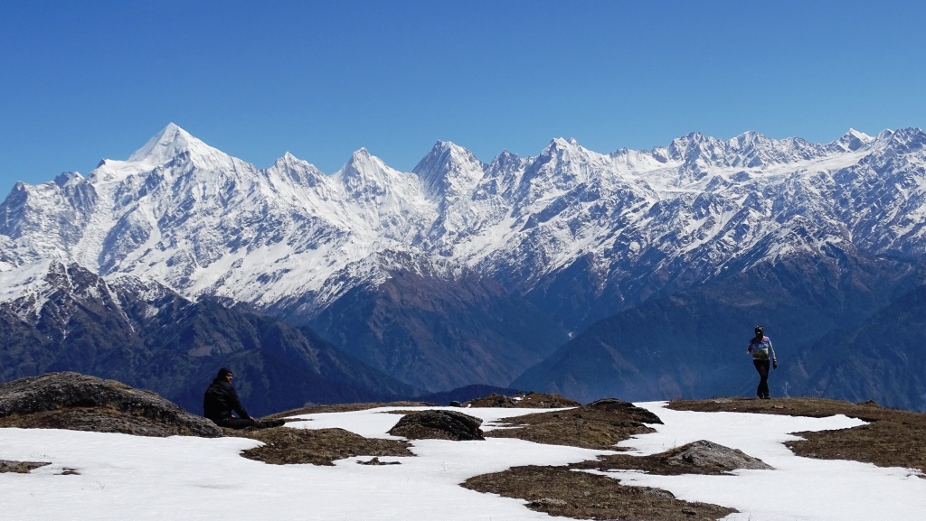
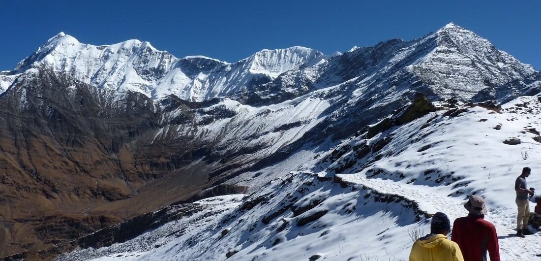
As you can see in the below mentioned photo we had a wonderful morning view on 10thday. There we started our exciting journey from Aizwal, where the cyclist “Michael” came with us till town’s boundary to show the proper route for Kolasib. We took breakfast in between the route and there we met some beautiful local kids riding their cycle.

As mentioned in the photo. We had lots of fun with them as the road views were tremendously beautiful and we took lots of selfies and photos. The last 5 kilometers were bit problematic as one of my team member’s head light was discharged and his cycle was also not in proper maintained condition. So I helped him by exchanging my cycle with him and reached Kolasib tourist lodge at 7:00 p.m… And that’s how we covered 80.4 kilometers on that day.

Total Distance covered 80.4 km on day 10.


Day 11 (25/12/2018)

Kolasib (Mizoram) to Fulertal (Assam)

pinal parlekar cycling

On 11th Day as per our plan we again started our journey from “Kolasib” to “Jiribam”. The road was quite well with uphill and downhill. It was an ok day without any special moment and we reached to “Fulertal” at 7:50 p.m.. Though the distance to reach “Jiribam” was only 18 kilometers, one of the local reside told us that not to take risk ahead as the area is not safe at night so we decided to have a night stay at “Fulertal” only. That’s how we covered 111.7 kilometers on that day.

Total Distance covered 111.7 km on day 11.


Day 12 (26/12/2018)

Fulertal (Assam) to Nungba (Manipur)

On 12th day we crossed Assam – Manipur border and entered in “Jiribam” one of the village in “Manipur” where we took our breakfast. In the middle of the journey we met very beautiful local people as you can see in the photos. It was first day of their new year after Christmas occasion so they were all dressed beautifully in their traditional way with lovely makeup.

We continued our ride till “Barak” a village situated on river “Barak” and from there we had a gradual pressure ride towards “Nungba” which was 20 kilometers. There we couldn’t find any proper stay as there were no hotels or lodge. So we came to know from locals that one of the Naga Family allows stay with guest facility with dinner for tourist. So we decided for night stay over there.

Total Distance covered 107.3 km on day 12.


Day 13 (27/12/2018)

Nungba (Manipur) to Imphal (Manipur)

The Next day we took selfies with the local kids as a token of our love and started our journey at 7:43 a.m.. The ride was relaxing as the road was downhill and normal slopes. In the middle of the route we met a lady “Sangeeta Sridhar” who was on a “Clean India trail Mission” with a solo drive in “Hexa Mahindra” covering 240 cities. It was an honor to meet such an inspiring personality. We took a little bit more time in between due to uphill for some kilometers but somehow we reached to our decided location “Imphal” as the last 35 kilometers were totally downhill with proper highway which gave us a relaxing ride. That’s how we covered 121.9 kilometers on that day.

Total Distance covered 121.9 km on day 13.


Day 14 (28/12/2018)

Imphal (Manipur) to Mao (Manipur)

We started our day with servicing the cycle in morning 5:30 a.m.. We were invited by the locals for flag off at “Kangla fort” gate. The media also supported and inspired us by taking our interview. After that one of the respectable Priest “Father Francies” honored us by putting their traditional Scarf and took us to visit a Christian school “Don Bosco” where he is servicing as Principal and also there we met one of the physically challenged cyclist name “BinayKumarShahu” who was also on a solo trip in that area.

It was an immense surprise and inspiration that father Francies a 63 year old paralyzed by left hand still use to ride cycle individually without any support vehicle. And it was a breathtaking surprise that “Binay Kumar Sahu” who was not having a left hand and use to ride cycle solo and that also without any support vehicle. After meeting these two personalities we realized that we still are a learner and needs tremendous practice.

Then we started our Journey towards “Kohima” capital of “Nagaland”. The trip was totally boring as the road was totally in worst condition full of dusty due under construction condition. We reached to “Mao” a village, but as it was already more than 9:00 p.m. and the weather at night in that area was very cold, we decided our night stay at “Mao”. That’s how we completed 108.2 kilometers on that day.

Total Distance covered 108.2 km on day 14.


Day 15 (29/12/2018)

Mao (Manipur) to Bokajan (Assam)

The 15th day was one of my unforgettable day in this trip. The atmosphere in the morning was too much cold than our assumption. But we still started our journey at morning 6:41 a.m. We reached the first police check post of “Khuzama Kohima Nagaland” the police staff welcomed us with warm tea and gave us some helpful instructions.

Then within 15 minutes we resumed our journey towards “Kohima”. After reaching there, we went to state police control room Nagaland to inform them about our expedition and entry in the logbook. Then we reached to “Dimapur” city of Nagaland at 5:30 p.m. As we got a telephonic reservation for stay at a hotel in “Bokajan” city of Assam.We decided to cover 18 kilometers extra to reach for the night stay location. In between those 18 kilometers I faced a problem at last 2 kilometers with 2 of my team members. The route was mismanaged by them and then we had an argument on that after reaching to the hotel at TNC Bhavan Bokajan. Our Leader named “Nizamuddin” gave a silly reason and ask me to leave the expedition.

Total Distance covered 121.2 km o day 15.


30/31 December 2018

Today morning at 6:05 a.m. our leader Nizamuddin and another team member named “Bharat Chaudhary” from Gujarat separated me from the team and continued their journey without informing me and another team member “Ghanshyam Raghuwanshi” who got injured during the trip and took all the cycles with them in the supporting vehicle.

Departing with no reason, my senior team member and leader in a very unusual and inhuman way shocked me a lot. However being an alone female in an expedition I didn’t lose my passion and courage and even for a single moment didn’t thought to give up as it was my dream to complete it at any way, which nobody has done earlier in the history of cycling expedition of north east state of India.

Me and my team member “Ghanshyam Raghuwanshi” were almost broke up due to such deception by our team members. I am a mountaineer since 2015 and he is also a mountaineer since long time, so by nature we learned so many things and one important thing that we learnt is to stay calm and do brain storming for different solutions of the problem. So in that situation we stayed calm started to find different solutions for the present problem as my willpower and aim was to complete this expedition by hook or crook. So we decided not to give up and first we called my parents and told them about incident.

They were in tension and worried about me because I was somewhere in North-East region which was totally new place for me. But my friend Ghanshyam talked with my father and assured him for my safety and handled the situation very well. Then my parents got agreed with my decision and allowed me to continue my journey which enhanced and boosted my willpower to complete my goal.

After that we contacted our cyclist friends who are in contact with us and asked for help. We got one of the local cyclist friend contact named “Marnungden Walling” and told him the entire incident. Being affectionate for us he told us not to worry and not to give up. He came to our location in his car and took us to his cousin’s place to manage another cycle for me. The cycle was not in proper serviced condition as I needed to cover long distance, so I called another friend named “Supuraj Gogai” from “Guwahati” and asked him for help. He informed us that one of his friend in Nagaland owns a cycle showroom and told us to visit there for new cycle.

As it was Sunday the showroom was closed so we came back to our hotel and stayed there. Next day morning 9:30 a.m. we reached to the showroom and it was my lucky day that there was only one piece of cycle of same company and model which I needed. My friend Ghanshyam helped me to buy that new cycle with all cycle accessories from Dimapur, Nagaland. Then we need to arrange a support vehicle, but as it was 31st December we couldn’t find any. So we requested an auto driver to come with us up till Golaghat (70 kilometers) as our supporting vehicle. It was full of pressure and tension on me and my friend for those 2 days. But with a positive and supportive help from our friends mentioned above we were able to continue the journey from next day.

On 31 Dec 2018, Cycle bill which I bought from Dimapur, Nagaland.


Day 16 (01/01/2019)

Bokajan (Assam) to Majuli (Assam)

Early in the morning 5:30 a.m. with New Year of 2019 and with new positive beliefs I started my journey with new cycle from “Bokajan to Majuli”. We reached to “Golaghat” 70 kilometers from “Bokajan” and there we arranged a new 4 wheeler as our supporting vehicle. We were very Thankful to the Auto driver “Vidhyut” who helped us in our bad time.

Upto 132 Kilometers it was all straight and perfect road. But after that we reached to Bhramputra,Neamatighat at 2:20 p.m..But the ferry was already departed. So we took our Lunch their and waited for next ferry trip. The next ferry trip was at 3:30 p.m. and so we crossed the Bhramputra River and continued our journey. “Majuli” was only 7 kilometers after crossing Bhramputra River. So I and my supporting vehicle continued our journey and reached to Majuli at 5:00 p.m… After separating from those two members I realized that solo I can cover more distance. So I was fortunate that they left me and my injured friend for solo ride.

It was 5:00 p.m. and we were totally ready to cover more distance but we have to cross another part Bhramputra River through ferry which was closed after 5:00 p.m. So we decided to stay at “Majuli” for night stay. That’s how I completed my first solo ride covering 149 Kilometers.

Total Distance covered 149 km on day 16.


Day 17 (02/01/2019)

Majuli (Assam) to Bishwanath Chariali (Assam)

Majuli is a largest river island of Asia and it’s famous for its traditions and its vibrant culture.

I started my trip at 6:03 a.m… The road totally messed up and we also use to cross a farm in between which was very tough for our supporting vehicle as well. But still we covered and reached to ferry on time.

After crossing Bhramputra River we went to “Itanagar” capital of “ArunachalPradesh”. We reached Superintendent of Police’s office at 1:45 p.m.. There we completed our procedure of logbook and verifications and then we took lunch. After Lunch we resumed our journey and covered 160 kilometers. Before 15 kilometers from “Bishwanath Chariali” had an awesome dinner in just 130 rs. for 3 persons and that also tasty and delicious. After that the locals over there had conversation with our Assamese driver who told them about our expedition, they were so surprisingly inspired and they honored me and my team member with Assam traditional scarf which known as “Gomcha” in local language. The locals were very helpful and guided us to stay at “Bishwanath Chariali” as there are good staying facilities in hotel. We reached at 10:00 “Bishwanath Chariali” covering 175.5 kilometers in solo ride.

Total Distance covered 175.5 km on day 17.


Day 18 (03/01/2019)

Bishwanath Chariali (Assam) to Dispur (Assam)

Today I was full of confidence with a fixed goal in my mind to reach “Dispur” capital of Assam from where we started our journey. So I started my journey along with my injured friend in supporting vehicle at 6:12 a.m. and reached to first rest point Debendra Nagar and took our breakfast there. After breakfast we resumed our journey towards “Tezpur” a bit slow from our decided time. After crossing “Nagaon” we got a proper highway with fully perfect 4 lane road which help us to cross maximum distance with short time. In between the highway we use to stop only for 10 minutes for minor break for water and light snacks and took lunch at Amoni. We continued our ride till “Jogiroad” at 8:00 p.m., and took our dinner and rest for 1 hour there.

With a constant focus on my goal I decided to carry on the trip and started my journey at 9:00 p.m. again to reach to the last and final location of this trip “Assam Dispur state zoo” where we started our expedition. In between there was a light rainfall but that didn’t stop me to continue my trip and at last 11:11 p.m. I reached to the flag off point. My other two deceptive team members reached to the spot just 1 day before which make me realized that I am much faster and better than them and if I would have covered this trip in a solo ride I would have covered it within 16 days. Anyways “Where there is a will there is a way”.

Total Distance covered 237.9 km on day 18.


Special thanks to whom, who is part of my success: I am truly grateful to the all friends, colleague, senior official, government authority, state police department and others who supported and motivated me to complete the very courageous expedition within the stipulated time frame. Without their support and help probably I could not have completed my goal as specified.

My parents who always been very supportive. I personally thank following members who helped and supported me for completion of cycling expedition, namely: Ghanshyam Raghuwanshi He taught me about how to do paddling in uphill and how to do cycle servicing and some basic things of cycle. With his support and encouragement I have successfully completed my cycling expedition and It worth to mention here that Ghanshyam Raghuwanshi , encountere an accident during our cycling expedition and his left shoulder got fractured on the way to cycling, due to fall, slip at downhill area of Meghalaya state.